
Cardinal direction
From Wikipedia, the free encyclopedia

The four cardinal directions or cardinal points are north, south, east, and west. Most commonly used for geographic orientation on Earth, they may be calculated anywhere on a rotating astronomical body. North and south point toward the poles defined by the axis of rotation. East and west orthogonally point along and opposite the direction of rotation. Intermediate points between the four cardinal directions form the compass rose and the points of the compass.
South is always directly opposite north. To an observer facing north and standing upright, east and west are always to the right and left, respectively. Most devices for finding orientation thus operate by finding north first. (Any other direction works equally well, if it can be reliably found.) Several such devices are described below.
Contents |
[edit] Locating the directions
[edit] Compass
Most commonly, a magnetic compass is used to approximate the true cardinal directions. Such devices take advantage of the close alignment of the Earth's magnetic field to its axis. In the simplest form, a mechanical needle points toward magnetic north, which is taken simply to be true north. Compasses are disturbed by local magnetic fields, which may result from geographic features, such as mountains, or nearby metal equipment, especially if it is electrically powered and unshielded.
[edit] The Sun
Most approximately, the Sun can be used for orientation if one knows the general time of day. In the morning, the Sun is in the east. Around noon, it is in the south in the northern hemisphere, or in the north in the southern hemisphere. After noon, the Sun sets in the west.
[edit] Watch face

An analogue watch clock face can be used to locate north and south. The Sun in the sky revolves over 24 hours, the hour hand of a 12-hour clock face in 12 hours. Therefore, in the Northern Hemisphere, rotate the watch such that the hour hand points towards the Sun. Then, the point halfway between the hour hand and 12 o'clock points towards the south. There are minor inaccuracies due to the difference between local time and zone time, and due to the equation of time. During daylight saving time, the same method can be employed using 11 o'clock instead of 12.
In the Southern Hemisphere, the same holds for the northern direction. The method works poorly at lower latitudes.
The photograph shows a specialized 24-hour watch optimized for finding directions using the Sun. With the watch set to indicate local time, the hour hand points directly at the Sun. North is indicated by the local midnight position (in the Northern Hemisphere).
[edit] Nighttime stars
Astronomy provides more reliable direction finding at night. The Earth's axis is currently (but not permanently) pointed, to within a fraction of 1 degree, toward the bright star Polaris. The exact direction of the axis changes over thousands of years due to the precession of the equinoxes. We call the end of the Earth's axis that points to Polaris the North Pole. The opposite end of the axis is named the South Pole. Polaris is also known as the North Star, and is generically also called a lodestar. Polaris is only visible during fair weather at night to inhabitants of the Northern Hemisphere.
Picking out a specific single star may leave one uncertain they've found the right one. As an aid to identifying Polaris, the asterism "Big Dipper" may be employed. The 2 corner stars of the "pan" (those opposite from the handle) point above the top of the "pan" to Polaris. This is illustrated at this example, the beginning of a tutorial that teaches how to find Polaris. To see the rest of the tutorial click the link at the bottom of the illustration.
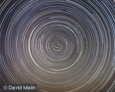
From the Southern Hemisphere, nightly observations of the sky directly above the vicinity of the true pole will reveal that the visible stars appear to be moving in a circular path. (It is actually the observer that is moving in the circular path.) This becomes completely obvious when a special case of long exposure photography is employed to record the observations, by locking the shutter open for most of the intensely dark part of a moonless night. The resulting photograph reveals a multitude of concentric arcs (portions of perfect circles) from which the exact center can be readily derived. The common center is exactly aligned with the true (as opposed to the magnetic) pole. (This also is true of the Northern Hemisphere, and can be used to verify one has correctly identified Polaris, which will not appear to move.) A published photograph exposed for nearly 8 hours demonstrates this effect. Note that many digital cameras will exhaust their battery before achieving the excellent result illustrated here. Either provide an external power source, or use a film-based camera, to duplicate this effect.
[edit] Inertial navigation
At the very end of the 19th century, to avoid the need to wait for fair weather at night to precisely verify one's alignment with true north, the gyrocompass was developed for ship use in scenarios where the magnetic compass simply wasn't good enough. It has the further advantages of immunity to interference by stray magnetic fields, and not depending on Earth's magnetic field at all. Its major disadvantage is that it depends on technology that many individuals might find too expensive to justify outside the context of a large commercial or military operation. It also requires a continuous power supply for its motors, and that it be allowed to sit in one location for a period of time while it properly aligns itself.
[edit] Satellite navigation
Near the end of the 20th century the advent of satellite-based Global Positioning Systems (GPS) provided yet another means for any individual to determine true north accurately. While GPS Receivers (GPSRs) work best with a clear view of the entire sky, they work day or night, and in all but the most severe weather. The government agencies responsible for the satellites continuously monitor and adjust them to maintain their accurate alignment with the Earth. There are consumer versions of the receivers that are attractively priced. Since there are no periodic access fees, or other licensing charges, they have become widely used. Handheld GPSRs have modest power requirements, can be shut down as needed, and become calibrated again within a couple of minutes of being restarted. In contrast to the gyrocompass, which is most accurate when stationary, the GPS receiver must be moving, typically at least more than 0.1 mile per hour, to correctly display compass directions. Within these limitations GPSRs are considered both accurate and reliable. The GPSR has thus become the fastest and most convenient way to obtain a verifiable alignment with both true north and true south.
Once the north-south orientation of the Earth's axis is known with precision, east and west are further refined as following arcs running in planes which are perpendicular to the Earth's axis.
[edit] Additional points
The directional names are also routinely and very conveniently associated with the degrees of rotation in the unit circle, a necessary step for navigational calculations (derived from trigonometry) and/or for use with Global Positioning Satellite (GPS) Receivers. The four cardinal directions correspond to the following degrees of a compass:
- North (N): 0° = 360°
- East (E): 90°
- South (S): 180°
- West (W): 270°
An ordinal, or intercardinal, direction is one of the four intermediate compass directions located halfway between the cardinal directions.
- Northeast (NE), 45°, halfway between north and east, is the opposite of southwest.
- Southeast (SE), 135°, halfway between south and east, is the opposite of northwest.
- Southwest (SW), 225°, halfway between south and west, is the opposite of northeast.
- Northwest (NW), 315°, halfway between north and west, is the opposite of southeast.
These 8 words have been further compounded, resulting in a total of 32 named (and numbered) points evenly spaced around the compass. It is noteworthy that there are languages which do not use compound words to name the points, instead assigning unique words, colors, and/or associations with phenomena of the natural world.
[edit] Usefulness of cardinal points
With the cardinal points thus accurately defined, by convention cartographers draw standard maps with north (N) at the top, and east (E) at the right. In turn, maps provide a systematic means to record where places are, and cardinal directions are the foundation of a structure for telling someone how to find those places.
North (N) does not have to be at the top. Portable GPS-based navigation computers can be set to display maps either conventionally (N always up, E always right) or with the current instantaneous direction of travel, called the heading, always up (and whatever direction is +90° from that to the right).
The direction of travel required to reach the intended destination is called the bearing. Since the real world presents numerous obstacles, one must adjust his or her heading accordingly. Upon moving forward, the bearing will change so that it always points at the destination, thereby giving clues as to which way one should turn. When you are traveling, it can be easier to figure out where your next turn is, and whether to turn left or right, when the direction of travel is always up.
[edit] Beyond geography
Children are sometimes taught the order of these directions (clockwise, from North) by using a mnemonic, such as "Naughty Elephants Squirt Water," "Never Eat Soggy Waffles", "Never Eat Shreaded Wheat" ("Soggy Weet-bix" in Australia & New Zealand), "Never Enter Stinky Washroom, "Never Eat Slimy Worms," or "Never Eat Sea Weed." Also, "West and East spell WE."
In mathematics, cardinal directions or cardinal points are the six principal directions or points along the x-, y- and z-axis of three-dimensional space.
In the real world there are six cardinal directions not involved with geography which are north, south, east, west, up and down. In this context, up and down relate to elevation or altitude. The topographic map is a special case of cartography in which the elevation is indicated on the map, typically via contour lines.
[edit] Germanic origin of names
During the Migration Period, the Germanic languages' names for the cardinal directions entered the Romance languages, where they replaced the Latin names borealis (or septentrionalis) with north, australis (or meridionalis) with south, occidentalis with west and orientalis with east. It is possible that some northern people used the Germanic names for the intermediate directions. Medieval Scandinavian orientation would thus have involved a 45 degree rotation of cardinal directions.[1]
- north (Proto-Germanic *norþ-) from a root *ner- "left, below", i.e. "to the left of the rising Sun".
- east (*aus-to-) from the word for dawn, see Eostre.
- south (*sunþ-) is root-cognate to Sun itself, thus "the region of the Sun"
- west (*wes-t-) from a word for "evening", root-cognate to Latin vesper.
[edit] Cardinal directions in world cultures
Many cultures not descended from European traditions use cardinal directions, but have a number other than four. Typically, a “center” direction is added, for a total of five. Rather than the Western use of direction letters, properties such as colors are often associated with the various cardinal directions—these are typically the natural colors of human perception rather than optical primary colors. Some examples are shown here; for more (esp. with regard to American Indian tribes) see Colors of the Four Directions.
In many regions of the world, prevalent winds change direction seasonally, and consequently many cultures associate specific named winds with cardinal and ordinal directions. The classical Greeks personified these winds as Anemoi. The article on boxing the compass contains a more recent list of directional winds from the Mediterranean Sea.
[edit] Far East
| Asia | N | E | S | W | C | Source |
|---|---|---|---|---|---|---|
| China | [2][3] | |||||
| Ainu | [4][5] | |||||
| Turkic | [4] | |||||
| Kalmyks | — | [6] | ||||
| Tibet | [4] |
Dynastic Chinese culture and some other Central Asian cultures view the center as a fifth principal direction hence the English translated term "Five Cardinal Points". Where it is different than the west, is that the term is used as a foundation for I Ching, the Five Elements and the five Naked-eye planets.
Each direction is often identified with a color, and geographical or ethnic terms may contain the name of the color instead of the name of the corresponding direction.[2][3] These traditions were also carried west by the westward migration of the Turkic peoples.
East: Green/Blue (青 "qīng" corresponds to green or blue); Spring; Wood
- Qingdao (Tsingtao) "Green Island": a city on the east coast of China
- Red River (Vietnam): south of China
- Red Sea: south of Turkey
- White Sheep Turkmen
- Ak Deniz "White Sea" in Turkish indicates the Sea of Marmara, the Aegean Sea, or the Mediterranean Sea
- Heilongjiang "Black Dragon River" province in Northeast China, also the Amur River
- Black Sea: north of Turkey
- Kara-Khitan Khanate
- Huangshan "Yellow Mountain" in central China
- Golden Horde: "Central Army" of the Mongols
[edit] Americas
| America | N | E | S | W | C | Source |
|---|---|---|---|---|---|---|
| Apache | — | [7] | ||||
| Aztec | — | [8][9] | ||||
| Cherokee | [4][10] | |||||
| Lakota | [4] | |||||
| Mayan | [4][8] | |||||
| Navajo | — | [4][7] | ||||
| Pueblo | — | [4][10] | ||||
| Sioux | — | [4] |
In Mesoamerica and North America, many traditional indigenous beliefs include four cardinal directions and a center. Each direction was associated with a color, which varied between groups but which generally corresponded to the hues of corn (green, black, red, white, and yellow). There seems to be no “preferred” way of assigning these colors; as shown in the table, great variety in color symbolism occurs even among cultures that are close neighbors geographically.
[edit] Non-English names of ordinal directions
In some languages, such as Finnish and Estonian, there are words for ordinal directions that are not compounds of the names of the cardinal directions (as, for instance, northeast is compounded from north and east). In Finnish those are (listed clockwise starting from northeast) koillinen, kaakko, lounas and luode.
[edit] Non-compass directional systems
Use of the compass directions is common and deeply embedded in European culture, and perhaps even more so in Chinese culture (see South Pointing Chariot). Some other cultures make greater use of other referents, such as towards the sea or towards the mountains (Hawaii, Bali), or upstream and downstream (most notably in ancient Egypt, also in the Yurok and Karok languages). Lengo (Guadalcanal, Solomon Islands) has four non-compass directions: landward, seaward, upcoast, and downcoast.[citations needed]
[edit] See also
- Azimuth
- Boxing the compass for all thirty-two English-named internationally-used principal points of the compass.
- Elevation - the mapping information ignored by the cardinal point system
- Geocaching - to learn about an internationally popular hobby & sport that depends on the above knowledge for success.
- Geographic Information System (GIS)
- Latitude and Longitude
- List of cartographers - about famous cartographers through history
- Magnetic deviation - to understand why a compass does not align perfectly with the earth's north and south poles.
- Orienteering - to learn about an internationally popular hobby & sport that depends on the above knowledge for success.
- South Pointing Chariot of China
- Uses of trigonometry
[edit] References
- ^ See e.g. Weibull, Lauritz. De gamle nordbornas väderstrecksbegrepp. Scandia 1/1928; Ekblom, R. Alfred the Great as Geographer. Studia Neophilologica 14/1941-2; Ekblom, R. Den forntida nordiska orientering och Wulfstans resa till Truso. Förnvännen. 33/1938; Sköld, Tryggve. Isländska väderstreck. Scripta Islandica. Isländska skällskapet årsbok 16/1965.
- ^ a b Cardinal colors in Chinese tradition. Retrieved on 2007-02-17.
- ^ a b Chinese Cosmogony. Retrieved on 2007-02-17.
- ^ a b c d e f g h i Colors of the Four Directions. Retrieved on 2007-02-17.
- ^ Two Studies of Color. Retrieved on 2008-03-14. “In Ainu... siwnin means both 'yellow' and 'blue' and hu means 'green' and 'red'”
- ^ Krupp, E. C.: "Beyond the Blue Horizon: Myths and Legends of the Sun, Moon, Stars, and Planets", page 371. Oxford University Press, 1992
- ^ a b Symbolism of Color. Retrieved on 2007-02-17.
- ^ a b Aztec Calendar and Colors. Retrieved on 2007-02-17.
- ^ The Aztec Gateway. Retrieved on 2007-02-17.
- ^ a b Native American Quotes & Proverbs. Retrieved on 2007-02-17.
|
||||||||

