

Imagine:CarthageMap.png
Da Wikipedia, ła ençiclopedia libara.
No xe mìa disponibili versioni a risoluzion piassè granda.
CarthageMap.png (770 × 447 pixel, dimensioni: 106 KB, tipo MIME: image/png)
Sto file el vien da Wikimedia Commons, par altre informazsioni varda ła só pàxena de descrizsion.
Se no te ghè mai usà Commons, varda ła pàxena de ben rivà, o lexi łe FAQ.
[edit] Summary
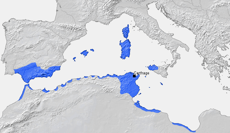
Location of Carthage and Carthaginian influence sphere before the First Punic War (264 BC)
Source: Self-made, based on Putzger Atlas und Chronik zur Weltgeschichte, Berlin, 2002
Template: [1]
Author: BishkekRocks
[edit] Licensing
| I, the copyright holder of this work, hereby release it into the public domain. This applies worldwide. In case this is not legally possible: Afrikaans | Alemannisch | Aragonés | العربية | Asturianu | Български | Català | Česky | Cymraeg | Dansk | Deutsch | Eʋegbe | Ελληνικά | English | Español | Esperanto | Euskara | Estremeñu | فارسی | Français | Galego | 한국어 | हिन्दी | Hrvatski | Ido | Bahasa Indonesia | Íslenska | Italiano | עברית | Kurdî / كوردی | Latina | Lietuvių | Latviešu | Magyar | Македонски | Bahasa Melayu | Nederlands | Norsk (bokmål) | Norsk (nynorsk) | 日本語 | Polski | Português | Ripoarisch | Română | Русский | Shqip | Slovenčina | Slovenščina | Српски / Srpski | Svenska | ไทย | Tagalog | Türkçe | Українська | Tiếng Việt | Walon | 中文(简体) | 中文(繁體) | zh-yue-hant | +/- |
Cronologia del file
Maca su un grupo data/ora par védar el file come el se presentava nel momento indicà.
| Data/Ora | Dimensioni | Utente | Ogeto | |
|---|---|---|---|---|
| corente | 15:31, 18 mar 2006 | 770×447 (106 KB) | BishkekRocks | (Location of Carthage and Carthaginian influence sphere before the First Punic War (264 BC) Source: Self-made, based on Putzger Atlas und Chronik zur Weltgeschichte, Berlin, 2002 Template: [http://www.demis.nl/wms/mapclip.htm] Author: ~~~ [[Category:Ca) |
Colegamenti a l'imagine
La pagina seguente la riciama sto file:

