画像:PIA05163.jpg
出典: フリー百科事典『ウィキペディア(Wikipedia)』

このプレビューのサイズ: 800 × 144 pixels
高解像度での画像 (6,398 × 1,150 ピクセル, ファイルサイズ: 546 キロバイト, MIMEタイプ: image/jpeg)
| このファイルはウィキメディア・コモンズから呼び出されたものです。 ページ・ノートへの記入や履歴などの詳細の確認はコモンズの画像説明ページ(ノート/履歴/ログ)を使用してください。 |
 ウィキメディア・コモンズの記述
| Description |
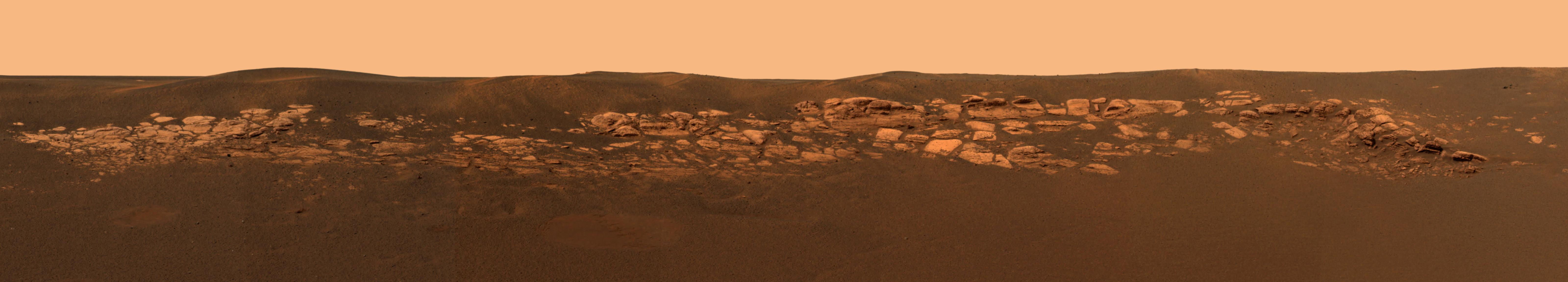
This high-resolution image captured by the Mars Exploration Rover Opportunity's panoramic camera highlights the puzzling rock outcropping that scientists are eagerly planning to investigate. Presently, Opportunity is on its lander facing northeast; the outcropping lies to the northwest. These layered rocks measure only 10 centimeters (4 inches) tall and are thought to be either volcanic ash deposits or sediments carried by water or wind. Data from the panoramic camera's near-infrared, blue and green filters were combined to create this approximate, true-color image. The Outcrop in a Nutshell Figure 1 highlights various rock targets within the outcrop lining the inner edge of the small crater where the rover landed. Opportunity recently finished examining the rock dubbed "Last Chance," then rolled over to "Wave Ripple," a section of rock in the region nicknamed "The Dells." Tomorrow, March 6, 2004, Sol 41, the rover will take a series of "touch-and-go" microscopic images at "Wave Ripple," before heading to another rock region with targets named "Slick Rock" and "Berry Bowl." |
|---|---|
| Source | |
| Date | |
| Author |
NASA/JPL/Caltech |
| Permission (Reusing this image) |
Original work of NASA - public domain |
|
|
This file is in the public domain because it was created by NASA. NASA copyright policy states that "NASA material is not protected by copyright unless noted". (NASA copyright policy page or JPL Image Use Policy).
Deutsch | English | Español | Français | Galego | Nederlands | Português | Русский | 中文(简体) | 中文(繁體) | +/- |
|
 |
Warnings:
|
ファイルの履歴
過去の版のファイルを参照するには、日付/時刻の列にあるリンクをクリックしてください。
| 日付/時刻 | 解像度 | 利用者 | コメント | |
|---|---|---|---|---|
| 現在の版 | 2007年5月17日 (木) 16:00 | 6,398×1,150 (546 キロバイト) | Clh288 | ({{Information |Description=This high-resolution image captured by the Mars Exploration Rover Opportunity's panoramic camera highlights the puzzling rock outcropping that scientists are eagerly planning to investigate. Presently, Opportunity is on its land) |
リンク
このファイルを使用しているページの一覧:

