
תמונה:1973 sinai war maps2.jpg
מתוך ויקיפדיה, האנציקלופדיה החופשית
גודל התצוגה הזו: 781 × 599 פיקסלים
תמונה ברזולוציה גבוהה יותר (1,165 × 894 פיקסלים, גודל הקובץ: 170 קילו־בייט, סוג MIME: image/jpeg)
| | זהו קובץ שמקורו במיזם ויקישיתוף. תיאורו בדף תיאור הקובץ המקורי מוצג למטה. |
[edit] Summary
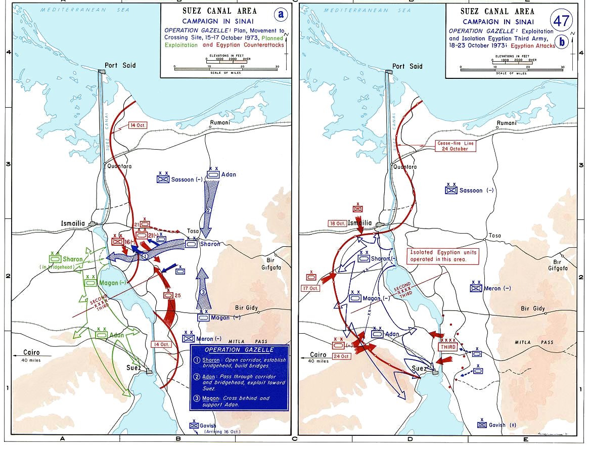
Sinai maps, from the US Military Academy History archives (copyright US government?)
- Source: Department of History, U.S. Military Academy
- URL: [1]
- Background information:
In 1938 the predecessors of what is today The Department of History at the United States Military Academy began developing a series of campaign atlases to aid in teaching cadets a course entitled, "History of the Military Art." Since then, the Department has produced over six atlases and more than one thousand maps, encompassing not only America’s wars but global conflicts as well.
In keeping abreast with today's technology, the Department of History is providing these maps on the internet as part of the department's outreach program. The maps were created by the United States Military Academy’s Department of History and are the digital versions from the atlases printed by the United States Defense Printing Agency. We gratefully acknowledge the accomplishments of the department's former cartographer, Mr. Edward J. Krasnoborski, along with the works of our present cartographer, Mr. Frank Martini.
Please be aware that these maps are large in file size and may require substantial download times.
| This image is a work of a U.S. Army soldier or employee, taken or made during the course of the person's official duties. As a work of the U.S. federal government, the image is in the public domain. |
 |
[edit] Licensing
| This work is in the public domain in the United States because it is a work of the United States Federal Government under the terms of Title 17, Chapter 1, Section 105 of the US Code. See Copyright.
Note: This only applies to works of the Federal Government and not to the work of any individual U.S. state, territory, commonwealth, county, municipality, or any other subdivision. العربية | Български | Česky | Deutsch | English | Español | Français | Magyar | Italiano | 日本語 | 한국어 | Polski | Português | 中文(繁體) | 中文(简体) | +/- |
 |
היסטוריית קובץ התמונה
לחצו על תאריך/שעה כדי לראות את התמונה כפי שהופיעה בעת זו.
| תאריך/שעה | ממדים | משתמש | הערה | |
|---|---|---|---|---|
| נוכחית | 02:54, 7 באוקטובר 2005 | 1,165×894 (170 קילו־בייט) | Wikiliki | (Sinai maps, from the US Military Academy History archives (copyright US government?) *Source: Department of History, U.S. Military Academy *URL: [http://www.dean.usma.edu/history/web03/atlases/map%20home.htm] *Background information: ''In 1938 the prede) |
קישורי תמונות
הדפים הבאים משתמשים בתמונה זו:

