画像:Usgs map azimuthal equidistant.PNG
出典: フリー百科事典『ウィキペディア(Wikipedia)』
高精細度の画像はありません。
Usgs_map_azimuthal_equidistant.PNG (487 × 162 ピクセル, ファイルサイズ: 46 キロバイト, MIMEタイプ: image/png)
| このファイルはウィキメディア・コモンズから呼び出されたものです。 ページ・ノートへの記入や履歴などの詳細の確認はコモンズの画像説明ページ(ノート/履歴/ログ)を使用してください。 |
 ウィキメディア・コモンズの記述
-
- (see below: Enlarged view)
[edit] Summary
| Description |
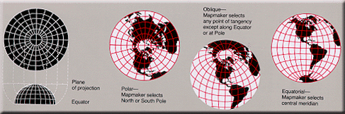
Condensed explanation of azimuthal-equidistant projection maps, colored as smaller PNG image, from larger, wider USGS file of GIF format. See enlarged view below, using a wikitable to expand beyond original size. |
|---|---|
| Source |
derivative from USGS image file (with map sections colored red/white), |
| Date |
17-February-2005 |
| Author |
User:Quadell, re-coloring US Government USGS image. |
| Permission (Reusing this image) |
(see below) |
| Other versions |
Taller arrangement of globes with enlarged lettering/clarified, up to 3x faster (GIF format): |
[edit] Enlarged view
 Explanation of azimuthal-equidistant projection. |
[edit] Licensing
| I, the copyright holder of this work, hereby release it into the public domain. This applies worldwide. In case this is not legally possible: Afrikaans | Alemannisch | Aragonés | العربية | Asturianu | Български | Català | Česky | Cymraeg | Dansk | Deutsch | Eʋegbe | Ελληνικά | English | Español | Esperanto | Euskara | Estremeñu | فارسی | Français | Galego | 한국어 | हिन्दी | Hrvatski | Ido | Bahasa Indonesia | Íslenska | Italiano | עברית | Kurdî / كوردی | Latina | Lietuvių | Latviešu | Magyar | Македонски | Bahasa Melayu | Nederlands | Norsk (bokmål) | Norsk (nynorsk) | 日本語 | Polski | Português | Ripoarisch | Română | Русский | Shqip | Slovenčina | Slovenščina | Српски / Srpski | Svenska | ไทย | Tagalog | Türkçe | Українська | Tiếng Việt | Walon | 中文(简体) | 中文(繁體) | zh-yue-hant | +/- |
| This image is in the public domain because it contains materials that originally came from the United States Geological Survey, an agency of the United States Department of Interior. For more information, see the official USGS copyright policy |
|
 |
This map image should be recreated using vector graphics as an SVG file. This has several advantages; see Commons:Media for cleanup for more information. If an SVG form of this image is already available, please upload it. After uploading an SVG, replace this template with template {{Vector version available|new image name.svg}} in this image. |
|
العربية | Български | Català | Česky | Dansk | Deutsch | English | Esperanto | Español | Français | Galego | 한국어 | Italiano | Magyar | Lietuvių | Nederlands | 日本語 | Polski | Português | Română | Русский | Suomi | Svenska | Türkçe | Українська | Tiếng Việt | मराठी | 中文(繁體) | 中文(简体) | +/- |
|
ファイルの履歴
過去の版のファイルを参照するには、日付/時刻の列にあるリンクをクリックしてください。
| 日付/時刻 | 解像度 | 利用者 | コメント | |
|---|---|---|---|---|
| 現在の版 | 2005年2月17日 (木) 14:25 | 487×162 (46 キロバイト) | Quadell | (World map projection ([http://erg.usgs.gov/isb/pubs/MapProjections/projections.html source)]{{PD-USGov-USGS}}Category:World mapsCategory:Map projectionsCategory:Map diagrams) |
リンク
このファイルを使用しているページの一覧:

