Immagine:Saskatchewanrivermap.png
Da Wikipedia, l'enciclopedia libera.
Non sono disponibili versioni a risoluzione più elevata.
Saskatchewanrivermap.png (500 × 348 pixel, dimensioni: 90 KB, tipo MIME: image/png)
Questo file e la sua pagina di descrizione si trovano su Wikimedia Commons.
Se non hai mai usato Commons, visita la pagina di benvenuto o leggi le FAQ.
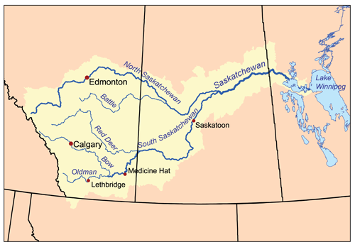
This is a map of the Saskatchewan River drainage basin. I, Karl Musser, created it based on USGS and Digital Chart of the World data.
|
Cronologia di questa immagine
Fare clic su un gruppo data/ora per vedere il file come si presentava nel momento indicato.
| Data | Dimensioni | Utente | Commento | |
|---|---|---|---|---|
| corrente | 18:34, 20 feb 2007 | 500×348 (90 KB) | Kmusser | (This is a map of the Saskatchewan River drainage basin. I, Karl Musser, created it based on USGS and Digital Chart of the World data. {{self|cc-by-sa-2.5}} [[C) |
Pagine che usano questa immagine
Le pagine seguenti richiamano questa immagine:

