Immagine:Champlainmap.png
Da Wikipedia, l'enciclopedia libera.
Non sono disponibili versioni a risoluzione più elevata.
Champlainmap.png (500 × 500 pixel, dimensioni: 34 KB, tipo MIME: image/png)
Questo file e la sua pagina di descrizione si trovano su Wikimedia Commons.
Se non hai mai usato Commons, visita la pagina di benvenuto o leggi le FAQ.
[edit] Summary
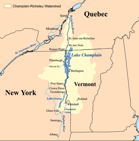
This is a map showing the Lake Champlain - Richelieu River watershed. I made using USGS, Census Bureau, and Digital Chart of the World data.
[edit] Licensing
|
Cronologia di questa immagine
Fare clic su un gruppo data/ora per vedere il file come si presentava nel momento indicato.
| Data | Dimensioni | Utente | Commento | |
|---|---|---|---|---|
| corrente | 19:29, 26 lug 2006 | 500×500 (34 KB) | Kmusser | |
| 19:02, 26 lug 2006 | 500×500 (34 KB) | Kmusser | (This is a map showing the Lake Champlain - Richelieu River watershed. I made using USGS, Census Bureau, and [[:en:Digital Chart of ) |
Pagine che usano questa immagine
Le pagine seguenti richiamano questa immagine:

