See also ebooksgratis.com: no banners, no cookies, totally FREE.

CLASSICISTRANIERI HOME PAGE - YOUTUBE CHANNEL
Privacy Policy Cookie Policy Terms and Conditions
Image:Map-Latin America2.png - Wikipédia

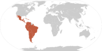
Image:Map-Latin America2.png

Un article de Wikipédia, l'encyclopédie libre.

Ci-dessous, retrouvez page de description du fichier provenant de Commons.

[edit] Summary

Español: Ubicación de América Latina
Same, but not zoomed

.

Map of en:Latin america. Thanks to write in the talk page if it's need to improve it. An alternative image is Image:Map-Latin America.png.

Map made from Image:BlankMap-World.png

Atelier graphique
Remarque
English: This map was made or improved by the Wikigraphists of the Atelier graphique. You can propose maps or images to clean up and improve as well.
Esperanto: Ĉi tiu mapo estis kreita aŭ plibonigita de la Vikigrafistoj el la Grafika laborgrupo. Vi ankaŭ povas tie proponi mapojnbildojn plibonigendajn.
Español: Este mapa ha sido confeccionado o mejorado por los Wikígrafos del Taller gráfico. Puedes proponer la mejora de cualquier imagen a través de la página de Peticiones.
Français : Cette carte a été créée ou améliorée par les Wikigraphistes de l'Atelier graphique. Vous pouvez également y proposer des cartes ou des images à améliorer.
Türkçe: Bu harita Atelier graphique'ten Wikigraphistes'ler tarafından yapıldı veya geliştirildi. Siz de haritalar veya resimleri temizlemek veya geliştirmek için teklif edebilirsiniz.


[edit] Licensing

Public domain This image has been released into the public domain by its author, Yug. This applies worldwide.

In some countries this may not be legally possible; if so:
Yug grants anyone the right to use this work for any purpose, without any conditions, unless such conditions are required by law.


العربية | Български | Deutsch | Ελληνικά | English | Español | Français | Italiano | 日本語 | 한국어 | Polski | Русский | Српски / Srpski | Svenska | தமிழ் | Українська | ‪中文(繁體)‬ | ‪中文(简体)‬  +/-

[edit] Atlas

This map should be added to the Wikimedia Atlas.

Historique du fichier

Cliquer sur une date et une heure pour voir le fichier tel qu’il était à ce moment-là

Date et heureDimensionsUtilisateurCommentaire
actuel25 février 2006 à 23:55390×450 (22 Kio)NoIdeaNick (Changed map to reflect the fact that Jamaica is not part of Latin America.)
19 janvier 2006 à 16:36390×450 (23 Kio)NoIdeaNick (Just a little change to the color of Belize.)
22 décembre 2005 à 01:29390×450 (20 Kio)Yug (Zoom)


aa - ab - af - ak - als - am - an - ang - ar - arc - as - ast - av - ay - az - ba - bar - bat_smg - bcl - be - be_x_old - bg - bh - bi - bm - bn - bo - bpy - br - bs - bug - bxr - ca - cbk_zam - cdo - ce - ceb - ch - cho - chr - chy - co - cr - crh - cs - csb - cu - cv - cy - da - de - diq - dsb - dv - dz - ee - el - eml - en - eo - es - et - eu - ext - fa - ff - fi - fiu_vro - fj - fo - fr - frp - fur - fy - ga - gan - gd - gl - glk - gn - got - gu - gv - ha - hak - haw - he - hi - hif - ho - hr - hsb - ht - hu - hy - hz - ia - id - ie - ig - ii - ik - ilo - io - is - it - iu - ja - jbo - jv - ka - kaa - kab - kg - ki - kj - kk - kl - km - kn - ko - kr - ks - ksh - ku - kv - kw - ky - la - lad - lb - lbe - lg - li - lij - lmo - ln - lo - lt - lv - map_bms - mdf - mg - mh - mi - mk - ml - mn - mo - mr - mt - mus - my - myv - mzn - na - nah - nap - nds - nds_nl - ne - new - ng - nl - nn - no - nov - nrm - nv - ny - oc - om - or - os - pa - pag - pam - pap - pdc - pi - pih - pl - pms - ps - pt - qu - quality - rm - rmy - rn - ro - roa_rup - roa_tara - ru - rw - sa - sah - sc - scn - sco - sd - se - sg - sh - si - simple - sk - sl - sm - sn - so - sr - srn - ss - st - stq - su - sv - sw - szl - ta - te - tet - tg - th - ti - tk - tl - tlh - tn - to - tpi - tr - ts - tt - tum - tw - ty - udm - ug - uk - ur - uz - ve - vec - vi - vls - vo - wa - war - wo - wuu - xal - xh - yi - yo - za - zea - zh - zh_classical - zh_min_nan - zh_yue - zu -