Imagen:1879 Lower Manhattan map.jpg
De Wikipedia, la enciclopedia libre
Dimensiones de esta vista previa: 402 × 599 píxeles
Ver la imagen en su resolución original (1.954 × 2.913 píxeles; tamaño de archivo: 1,45 MB; tipo MIME: image/jpeg)
| | Éste es un fichero de Wikimedia Commons, un depósito de contenido libre hospedado por la Fundación Wikimedia. Más abajo se reproduce su página de descripción con la información sobre su origen y licencia. |
[edit] Summary
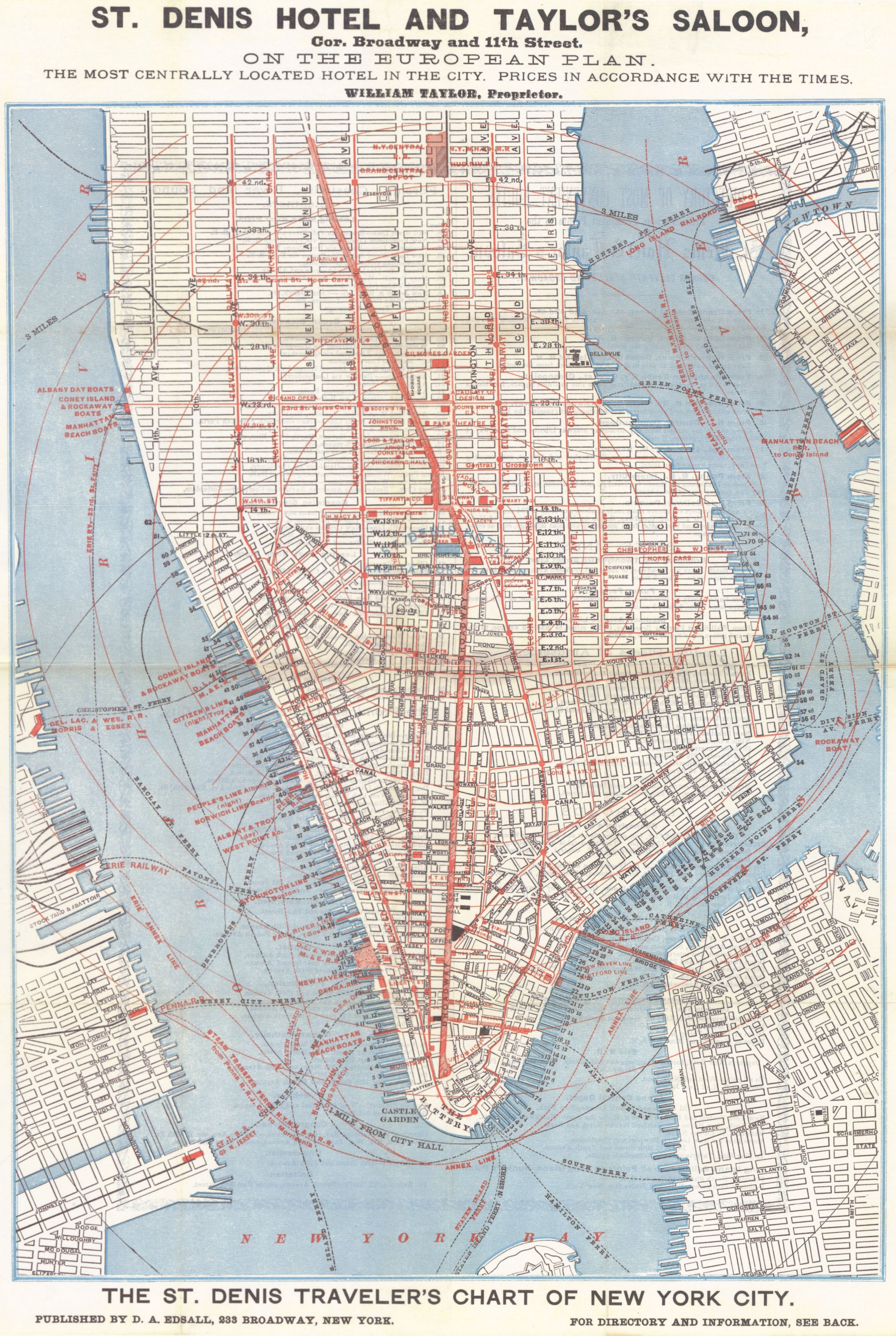
1879 map of Lower Manhattan showing streetcar lines, reproduced in Twelve Historical New York City Street and Transit Maps from 1860 to 1967.
[edit] Licensing
| This image (or other media file) is in the public domain because its copyright has expired. This applies to the United States, Canada, the European Union and those countries with a copyright term of life of the author plus 70 years.
العربية | Asturianu | Български | Català | Česky | Dansk | Deutsch | English | Ελληνικά | Esperanto | Español | Euskara | فارسی | Français | Gaeilge | Galego | עברית | हिन्दी | Bahasa Indonesia | Italiano | 日本語 | 한국어 | Kurdî / كوردی | Lietuvių | Magyar | Nederlands | Norsk (nynorsk) | Bahasa Melayu | Polski | Português | Română | Русский | Slovenčina | Slovenščina | Shqip | Suomi | Sámegiella | Türkçe | 中文(简体) | 中文(繁體) | 粵語 | +/- |
Historial del archivo
Haga clic sobre una fecha/hora para ver el archivo a esa fecha.
| Fecha/Hora | Dimesiones | Usuario | Comentario | |
|---|---|---|---|---|
| act | 20:48 13 mar 2005 | 1.954×2.913 (1,45 MB) | Paul Sinnett | (stitched) |
| 20:08 6 mar 2005 | 1.989×2.943 (1,84 MB) | SPUI | ({{PD}}1879 map of Lower Manhattan showing streetcar lines, reproduced in ''Twelve Historical New York City Street and Transit Maps from 1860 to 1967''.category:New York City Subway) |
Enlaces a la imagen
Las siguientes páginas enlazan a esta imagen:

