Bild:Hessen1930.png
aus Wikipedia, der freien Enzyklopädie
Größe der Voransicht: 424 × 600 Pixel
Version in höherer Auflösung (1.936 × 2.738 Pixel, Dateigröße: 86 KB, MIME-Typ: image/png)
| | Diese Datei wird aus dem zentralen, mehrsprachigen Dateiarchiv Wikimedia Commons eingebunden. Sämtliche Informationen unter dem roten Trennstrich stammen von der dortigen Beschreibungsseite der Datei. | |
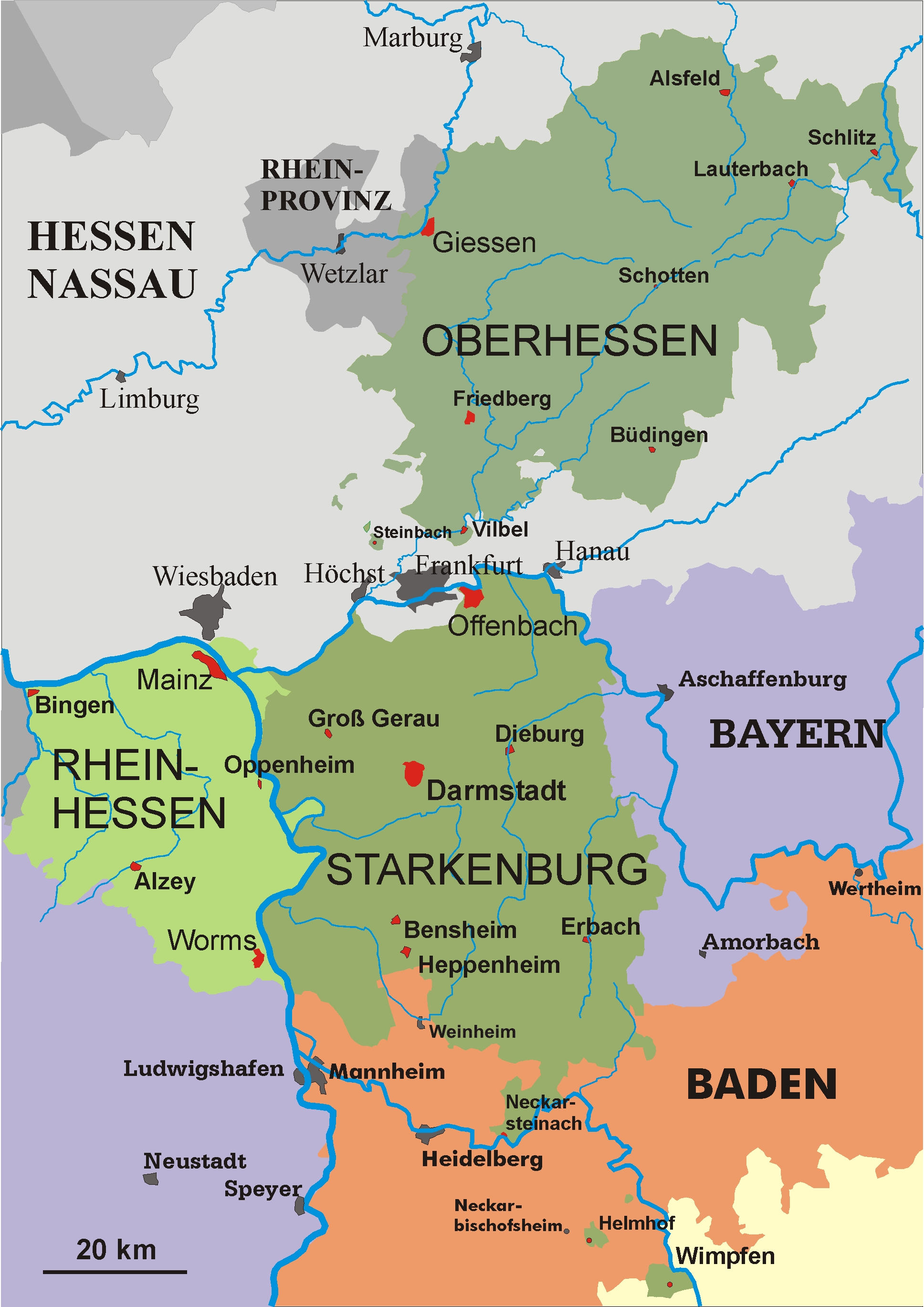
Korrektur: dort, wo Viernheim eingezeichnet ist, liegt WEINHEIM. Viernheim liegt im grünen Zipfel zwischen Mannheim und Weinheim!
| Description |
Karte Hessen 1930 selbst gezeichnet gemeinfrei |
|---|---|
| Source |
Originally from de.wikipedia; description page is (was) here |
| Date |
2004 |
| Author |
User Störfix on de.wikipedia |
| Permission (Reusing this image) |
Released into the public domain (by the author).Licensed under the GFDL by the author. |
| Other versions |
Originally from de.wikipedia; description page is (was) here |
| I, the copyright holder of this work, hereby release it into the public domain. This applies worldwide. In case this is not legally possible: Afrikaans | Alemannisch | Aragonés | العربية | Asturianu | Български | Català | Česky | Cymraeg | Dansk | Deutsch | Eʋegbe | Ελληνικά | English | Español | Esperanto | Euskara | Estremeñu | فارسی | Français | Galego | 한국어 | हिन्दी | Hrvatski | Ido | Bahasa Indonesia | Íslenska | Italiano | עברית | Kurdî / كوردی | Latina | Lietuvių | Latviešu | Magyar | Македонски | Bahasa Melayu | Nederlands | Norsk (bokmål) | Norsk (nynorsk) | 日本語 | Polski | Português | Ripoarisch | Română | Русский | Shqip | Slovenčina | Slovenščina | Српски / Srpski | Svenska | ไทย | Tagalog | Türkçe | Українська | Tiếng Việt | Walon | 中文(简体) | 中文(繁體) | zh-yue-hant | +/- |

(Uploaded using CommonsHelper or PushForCommons)
Dateiversionen
Klicke auf einen Zeitpunkt, um diese Version zu laden.
| Version vom | Maße | Benutzer | Kommentar | |
|---|---|---|---|---|
| aktuell | 16:41, 23. Sep. 2006 | 1.936×2.738 (86 KB) | Raymond | (Auf eine alte Version zurückgesetzt) |
| 08:02, 24. Jul. 2006 | 1.936×2.738 (228 KB) | Kjetil r | ({{Information| |Description= Karte Hessen 1930 selbst gezeichnet gemeinfrei |Source= |Date= |Author=User Störfix on [http://de.wikipedia.org de.wikipedia] |Permission= Released into the public domain (by the author).Licensed under) |
Verwendung
Die folgenden 26 Seiten verwenden diese Datei:
- Landkreis Alzey-Worms
- Landkreis Mainz-Bingen
- Großherzogtum Hessen
- Volksstaat Hessen
- Landkreis Worms
- Landkreis Oppenheim
- Landkreis Bingen
- Rheinhessen (Provinz)
- Wikipedia:Fragen zur Wikipedia/Archiv/2006/September/5
- Wikipedia:Kartenwerkstatt/Archiv/2007-10
- Kreis Bensheim
- Kreis Heppenheim
- Kreis Darmstadt
- Kreis Dieburg
- Kreis Erbach
- Kreis Lindenfels
- Kreis Wimpfen
- Kreis Neustadt
- Kreis Groß-Gerau (Starkenburg)
- Kreis Offenbach (Starkenburg)
- Regierungsbezirk Heppenheim
- Regierungsbezirk Erbach
- Regierungsbezirk Dieburg
- Regierungsbezirk Darmstadt (Starkenburg)
- Regierungsbezirk Mainz
- Regierungsbezirk Worms

