Grafika:LINE21.jpg
Z Wikipedii
Rozmiar podglądu: 800 × 552 pikseli
Obraz w wyższej rozdzielczości (1 000 × 690 pikseli, rozmiar pliku: 102 kB, typ MIME: image/jpeg)
| | Plik LINE21.jpg [ edytuj opis ] umieszczony jest w Wikimedia Commons, repozytorium wolnych zasobów projektów Fundacji Wikimedia. Wyjaśnienie podanej poniżej licencji znajdziesz na stronie Opisy licencji grafiki. |
| Description |
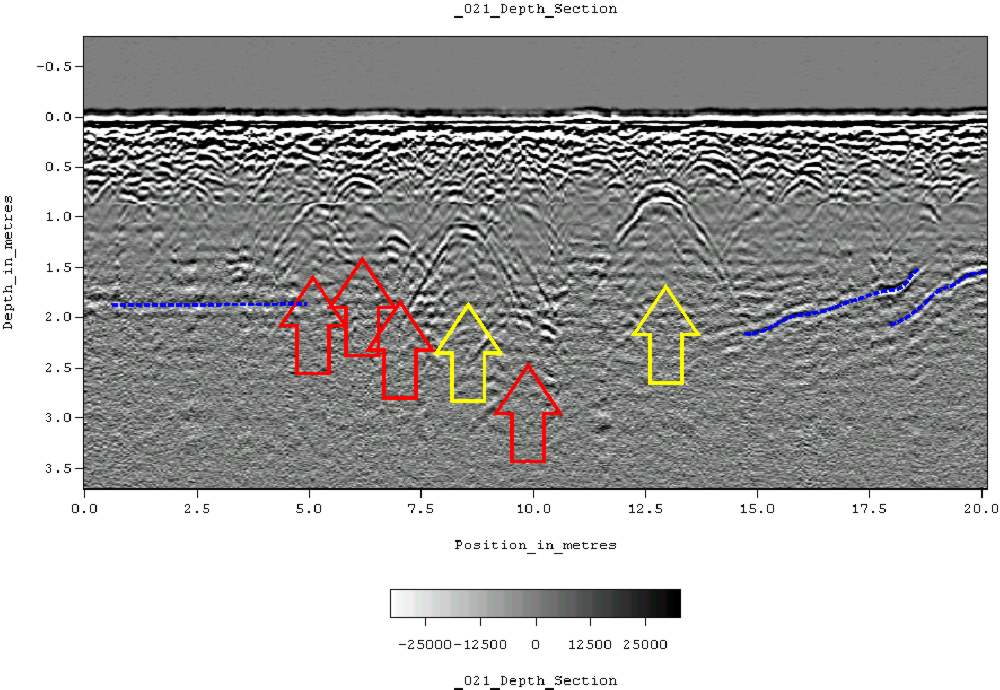
Ground-penetrating radar depth section (profile) collected on an historic cemetery in Alabama, USA. Yellow arrows indicate very distinct reflections, probably associated with human burials. "hyperbolic" reflections, appearing as an inverted U, are typically associated with discrete objects. Less distinct hyperbolic reflections are indicated by red arrows. dashed blue lines indicate horizontal and sloping reflectors, probably bedrock. The many smaller reflections near the surface are likely to be caused by tree roots. Because of the nature of the site, subsurface testing was not conducted, but these interpretations are supported by surface indications (grave markers and depressions) and with line-to-line patterning within the GPR data. |
|---|---|
| Source |
Originally from en.wikipedia; description page is/was here. |
| Date |
2007-06-11 (first version); 2007-06-11 (last version) |
| Author |
Original uploader was Tapatio at en.wikipedia |
| Permission (Reusing this image) |
Released into the public domain (by the author). |
[edit] License information
| This image has been (or is hereby) released into the public domain by its author, Tapatio at the wikipedia project. This applies worldwide. In case this is not legally possible: |
[edit] Original upload log
(All user names refer to en.wikipedia)
- 2007-06-11 05:16 Tapatio 1000×690×8 (104839 bytes) {{PD-self}}
- 2007-06-11 04:49 Tapatio 1000×690×8 (104839 bytes) Ground-penetrating radar depth section (profile) collected on an historic cemetery in Alabama, USA. Yellow arrows indicate very distinct reflections, probably associated with human burials. "Parabolic" reflections, appearing as an inverted U, are typicall
Historia pliku
Kliknij na datę/czas, aby zobaczyć, jak plik wyglądał w tym czasie.
| Data/czas | Wymiary | Użytkownik | Opis | |
|---|---|---|---|---|
| aktualny | 21:02, 17 paź 2007 | 1 000×690 (102 kB) | Conscious | (full resolution) |
| 21:22, 2 paź 2007 | 800×552 (105 kB) | Rosarinagazo | (Ground-penetrating radar depth section (profile) collected on an historic cemetery in Alabama, USA. Yellow arrows indicate very distinct reflections, probably associated with human burials. "hyperbolic" reflections, appearing as an inverted U, are typical) |
Odnośniki do pliku
Następujące strony odwołują się do tego pliku:

