Vaizdas:Claude Bernou Carte de lAmerique septentrionale.jpg
Straipsnis iš Vikipedijos, laisvosios enciklopedijos.
Sumažintos iliustracijos dydis: 640 × 600 tšk.
Didesnės raiškos iliustracija (3 946 × 3 697 taškų, failo dydis: 6,2 MiB, MIME tipas: image/jpeg)
| | Šis failas yra iš bendros Wikimedia Commons nemokamų resursų duomenų bazės, palaikomos Wikimedia Foundation organizacijos. |
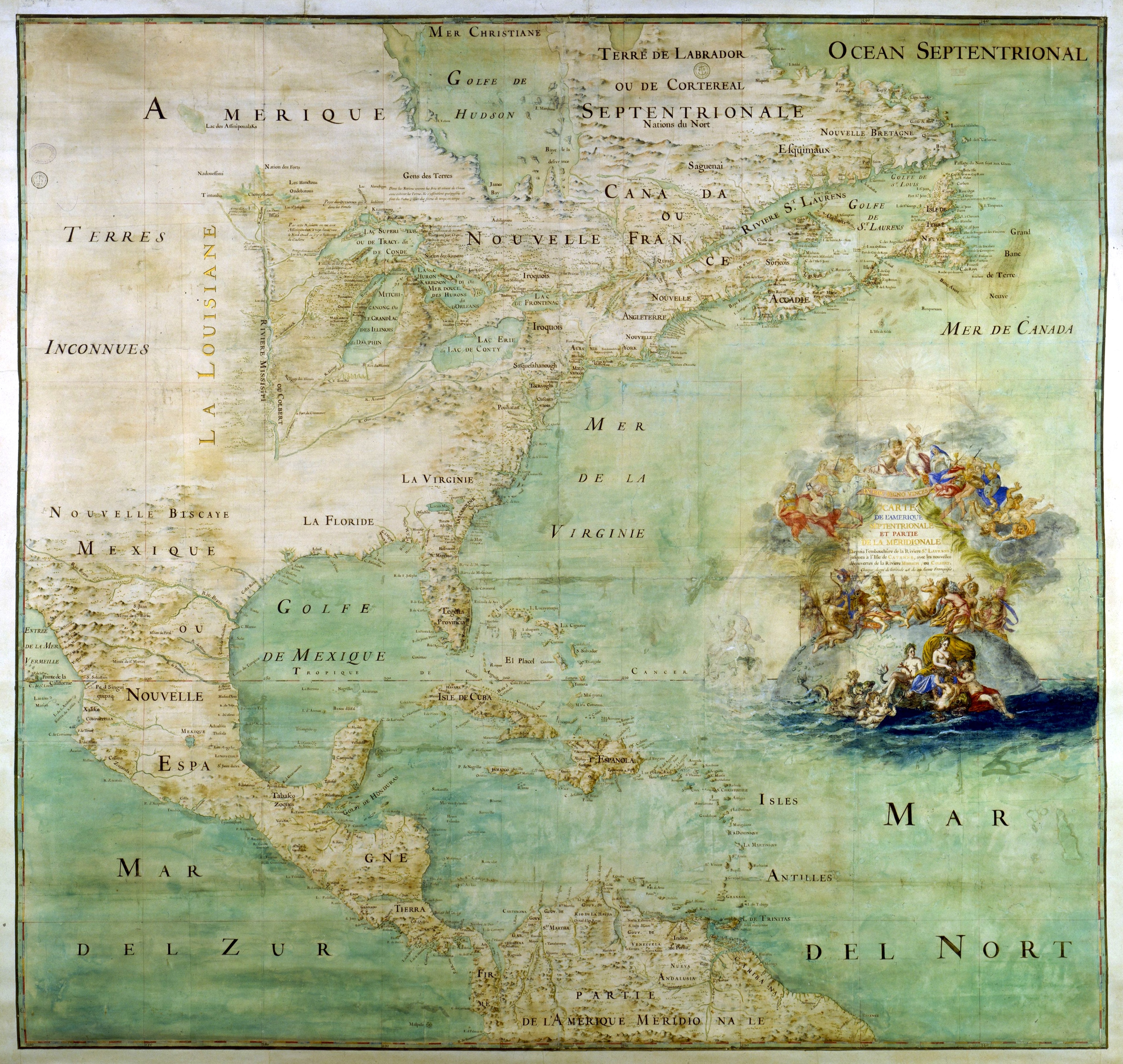
Auteur : Bernou, Claude (16..-17..?), abbé
Titre : Carte de l'Amérique septentrionale et partie de la méridionale depuis l'embouchure de la rivière St Laurens jusqu'à l'isle de Cayenne avec les nouvelles découvertes de la rivière de Mississipi ou Colbert [attribuée à l'abbé Bernou]
Éditeur : [ca 1681]
Collation : 1 carte, ms. col. , 163 x 147 cm
Author: Bernou, Claude (b. 16..-d. 17..), Abbot.
Title: Map of the northern part and parts of the southern parts of the America, from the mouth of the Saint Laurent River to the Island of Cayenne,with the new discoveries of the Mississipi (or Colbert) River. edited arount 1681.
|
|
This is a featured picture on Wikimedia Commons: it is considered one of our finest images. If you have an image of similar quality that can be published under a suitable copyright license, be sure to upload it, tag it, and nominate it. |
| This image was selected as a picture of the day for March 22, 2006. It was captioned as followed:
English: Early map of North America
Alemannisch: Alti Kart vun Nordamerika
Български: Ранна карта на Северна Америка (17 век)
Česky: Mapa Severní Ameriky ze 17. století.
Deutsch: Frühe Karte von Nordamerika
English: Early map of North America
Español: Antiguo mapa de América del Norte
Suomi: Vanha Pohjois-Amerikan kartta.
Français : Ancienne carte de l'Amérique du nord
Galego: mapa de America do Norte
Magyar: Észak-Amerika XVII. századi térképe
Italiano:
Antica mappa dell'America del Nord 日本語: 初期の北アメリカの地図
Lëtzebuergesch : Historesch Kaart vun Nordamerika.
Norsk (nynorsk): Tidleg kart over Nord-Amerika.
Polski: Siedemnastowieczna mapa Ameryki Północnej
Português: Mapa antigo da América do Norte
Русский: Древняя карта Северной Америки
中文(简体): 北美17世纪时的地图。
|
This photographic reproduction is therefore also in the public domain. العربية | Česky | Deutsch | English | Ελληνικά | Español | فارسی | Français | עברית | Bahasa Indonesia | Italiano | 日本語 | 한국어 | Magyar | Nederlands | Polski | Português | Română | Русский | Slovenščina | Српски / Srpski | Basa Sunda | Türkçe | Українська | 中文(繁體) | 中文(简体) | +/- |
|
Français : Cette image est une reproduction d'une œuvre bidimensionnelle tombée dans le domaine public. Pour cette raison, elle est considérée aux États-Unis d'Amérique comme une œuvre du domaine public.
La Bibliothèque nationale de France (BNF) a scanné cette image. Il est possible (mais loin d'être certain) qu'elle détienne, en France, des droits sur l'image scannée. Cependant, la BNF nous a donné autorisation pour l'utilisation de ses photographies sur nos sites et supports CD/DVD. Nous remercions la BNF de son aimable collaboration. Cette image peut être consultée sur le site Gallica (voir le lien direct ci-dessous). Voir aussi : Category:Gallica images.English: This image is a reproduction of a bidimensional work that is now in the public domain. For this reason, it is in the public domain in the United States of America.
The National Library of France (BNF) scanned this image. It is possible (but far from certain) that this makes BNF own some rights, in France, on the scanned file. However, BNF gave us the authorization to use any image from their database on our sites and CD/DVDs. We thank BNF for its kind collaboration. This image may be consulted on Gallica (see the direct link below). See also Category:Gallica images.Español: Esta imagen es una reproducción de una obra bidimensional que se encuentra en el dominio público. Por esta razón, está considerada como obra de dominio público en los Estados Unidos de América.
La Biblioteca Nacional de Francia (BNF) ha escaneado esta imagen. Es posible (pero poco probable) que la BNF retenga algunos derechos, en Francia, sobre el fichero escaneado. De todos modos, la BNF nos ha autorizado a utilizar cualquier imagen de su base de datos en nuestros sitios y CD/DVD. Agradecemos a la BNF por su amable colaboración. Esta imagen puede ser consultada en Gallica (ver el enlace directo abajo). Ver también Category:Gallica images.Gallica => Image IFN-08008861. |
Paveikslėlio istorija
Paspauskite ant datos/laiko, kad pamatytumėte failą tokį, koks jis buvo tuo metu.
| Data/Laikas | Matmenys | Naudotojas | Komentaras | |
|---|---|---|---|---|
| dabartinis | 23:12, 2005 gegužės 15 | 3 946×3 697 (6,2 MiB) | David.Monniaux | |
| 21:23, 2005 gegužės 15 | 3 792×3 576 (5,89 MiB) | David.Monniaux | ({{Français}} '''Auteur :''' Bernou, Claude (16..-17..?), abbé '''Titre :''' ''Carte de l'Amérique septentrionale et partie de la méridionale depuis l'embouchure de la rivière St Laurens jusqu'à l'isle de Cayenne avec les nouvelles décou) |
Paveikslėlio naudojimas
Paveikslėlis naudojamas šiuose straipsniuose:

