Imago:Via Popilia map.jpg
E Vicipaedia
Size of this preview: 569 × 600 pixels
Full resolution (1 052 × 1 109 pixel, file size: 642 chiliocteti, MIME type: image/jpeg)
| | Hic est fasciculus ex Vicimediis Communibus. Vide eius descriptionem apud Communia ut plura discas. |
[edit] Summary
This map is based on the following picture: Image:Satellite image of Italy in March 2003.jpg
[edit] Licensing
| I, the copyright holder of this work, hereby release it into the public domain. This applies worldwide. In case this is not legally possible: Afrikaans | Alemannisch | Aragonés | العربية | Asturianu | Български | Català | Česky | Cymraeg | Dansk | Deutsch | Eʋegbe | Ελληνικά | English | Español | Esperanto | Euskara | Estremeñu | فارسی | Français | Galego | 한국어 | हिन्दी | Hrvatski | Ido | Bahasa Indonesia | Íslenska | Italiano | עברית | Kurdî / كوردی | Latina | Lietuvių | Latviešu | Magyar | Македонски | Bahasa Melayu | Nederlands | Norsk (bokmål) | Norsk (nynorsk) | 日本語 | Polski | Português | Ripoarisch | Română | Русский | Shqip | Slovenčina | Slovenščina | Српски / Srpski | Svenska | ไทย | Tagalog | Türkçe | Українська | Tiếng Việt | Walon | 中文(简体) | 中文(繁體) | zh-yue-hant | +/- |
|
|
This file is in the public domain because it was created by NASA. NASA copyright policy states that "NASA material is not protected by copyright unless noted". (NASA copyright policy page or JPL Image Use Policy).
Deutsch | English | Español | Français | Nederlands | Português | Русский | 中文(简体) | 中文(繁體) | +/- |
|
 |
Warnings:
|
Historia fasciculi
Ad emendationem fasciculi inspiciendum, preme in diem/tempus.
| Dies/Tempus | Dimensiones | Usor | Summarium | |
|---|---|---|---|---|
| recentissima | 11:20, 28 Ianuarii 2008 | 1 052×1 109 (642 chiliocteti) | Salli | |
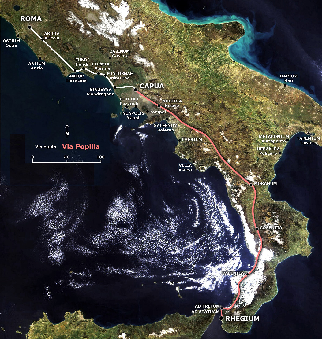
| 19:54, 4 Aprilis 2007 | 1 052×1 109 (647 chiliocteti) | Salli | ({{en|Map of the Popilian Way (or Via Capua-Rhegium) conjuncted to Appian Way.}} {{it|Mappa della Via Popilia (o Via Capua-Rhegium) collegata alla Via Appia.}} == Summary == This map is based on the following pictur) |
Nexus
Paginae sequentes ad hunc fasciculum nectunt:
Metadata
This file contains additional information, probably added from the digital camera or scanner used to create or digitize it. If the file has been modified from its original state, some details may not fully reflect the modified file.
| Orientation | Normal |
|---|---|
| Horizontal resolution | 200 dpi |
| Vertical resolution | 200 dpi |
| Software used | Adobe Photoshop CS3 Macintosh |
| File change date and time | 12:19, 28 Ianuarii 2008 |
| Color space | 65535 |

