
Kép:Bulgaria-SanStefano -(1878)-byTodorBozhinov.png
A Wikipédiából, a szabad enciklopédiából.
Az előnézet mérete: 769 × 600 képpont
A kép nagyfelbontású változata (786 × 613 képpont, fájlméret: 236 KB, MIME-típus: image/png)
| | Ez a fájl a Wikimedia Commonsból származik. Az alább látható leírás az ottani dokumentációjának másolata. A Commons projekt szabad licencű kép- és multimédiatár. Segíts te is az építésében! |
 |
This image (or all images in this category) uses inside labels or attached captions in a specific script or language and might be converted to a language neutral form. This would allow its use in all Wikimedia projects and, more importantly, all Wikimedia languages.
Deutsch | English | Español | Français | Italiano | 日本語 | 한국어 | Português | Slovenčina | Српски / Srpski | +/- |
 |
This map image should be recreated using vector graphics as an SVG file. This has several advantages; see Commons:Media for cleanup for more information. If an SVG form of this image is already available, please upload it. After uploading an SVG, replace this template with template {{Vector version available|new image name.svg}} in this image. |
|
العربية | Български | Català | Česky | Dansk | Deutsch | English | Esperanto | Español | Français | 한국어 | Italiano | Magyar | Lietuvių | Nederlands | 日本語 | Polski | Português | Română | Русский | Suomi | Svenska | Türkçe | Українська | Tiếng Việt | मराठी | 中文(繁體) | 中文(简体) | +/- |
|
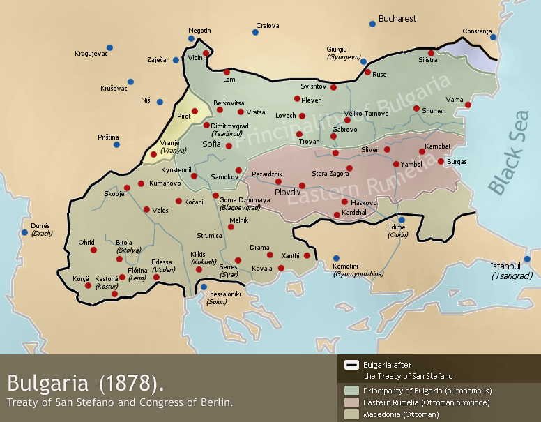
A map of liberated Bulgaria (1878) - borders after the Treaty of San Stefano (3 March 1878) and the Congress of Berlin (June 1878).
Drawn by Todor Bozhinov (me) and released under GFDL.
[edit] Licensing

Fájltörténet
Kattints egy időpontra, hogy a fájl akkori állapotát láthasd.
| Dátum/idő | Felbontás | Feltöltő | Megjegyzés | |
|---|---|---|---|---|
| jelenlegi | 2006. február 17., 18:12 | 786×613 (236 KB) | Martyr | (made darker, I discovered my monitor shows the colours somewhat dark and the image's actual colours are too light.) |
| 2006. január 26., 16:37 | 786×613 (229 KB) | Martyr | (Ruse inscription was somehow erased) | |
| 2006. január 24., 00:28 | 786×613 (229 KB) | Martyr | ("Principality of Bulgaria" and "Eastern Rumelia" inscriptions fixed, they were somehow partly deleted.) | |
| 2006. január 5., 01:28 | 786×613 (225 KB) | Martyr | (correction in the northeast - the piece of Dobruja that was part of San Stefano Bulgaria but was given to Romania after the Congress of Berlin now marked.) | |
| 2006. január 5., 01:11 | 786×613 (225 KB) | Martyr | ("Vranja" to "Vranje (Vranya)" - Vranje is the correct contemporary Serbian name, Vranya is a transliteration of the Bulgarian one.) | |
| 2006. január 4., 21:18 | 786×613 (226 KB) | Martyr | (fixed wrong western border with Serbia, Pirot and Vranja were Bulgarian territory according to the Treaty of San Stefano) | |
| 2006. január 1., 23:21 | 786×613 (228 KB) | Martyr | (A map of liberated Bulgaria (1878) - borders after the Treaty of San Stefano (3 March 1878) and the Congress of Berlin (June 1878). Drawn by [[:en:User:TodorBozhinov|Todor Bozhinov) |
Képhivatkozások
Az alábbi lapok hivatkoznak erre a képre:


-byTodorBozhinov.png)
-byTodorBozhinov.png)
-byTodorBozhinov.png)
-byTodorBozhinov.png)
-byTodorBozhinov.png)
-byTodorBozhinov.png)