Image:Rodrigues Island topographic map-fr.png
Un article de Wikipédia, l'encyclopédie libre.
Taille de cet aperçu : 637 × 600 pixels
Image en plus haute résolution (1 700 × 1 600 pixels, taille du fichier : 706 Kio, type MIME : image/png)
| | Ce fichier provient de Wikimedia Commons?. Les informations le concernant sont affichées ci-dessous (procédure). |
[edit] Summary
| Camera location | This and other geocoded Commons images: | (Info) |
|---|
| Description |
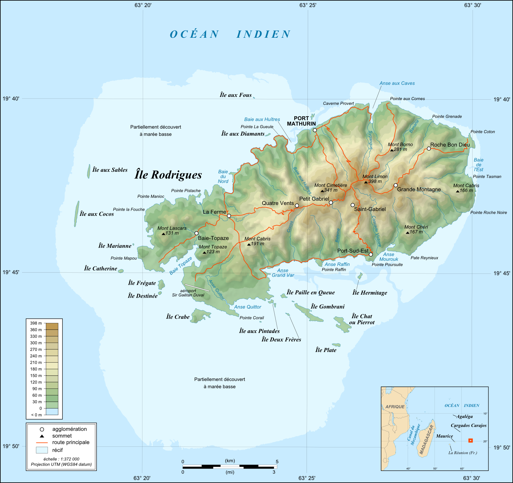
English: Topographic map in French of Rodrigues Island, Mauritius
Note : for translation purpose, use the SVG version Scale : 1:372,000 (accuracy : about 93 m) ; Printing size : 7.79 x 7.33 cm Français : Carte topographique en français de l'île de Rodrigues, Maurice
Échelle : 1:372 000 (précision : environ 93 m) ; Taille d'impression : 7,79 x 7,33 cm UTM projection, WGS84 datum |
||||
|---|---|---|---|---|---|
| Source |
English: Own work (see complete description on Image:Rodrigues_Island_topographic_map-fr.svg).
Français : Création personnelle (voir description complète sur Image:Rodrigues_Island_topographic_map-fr.svg).
|
||||
| Date |
May 2008 |
||||
| Author | |||||
| Permission (Reusing this image) |
GFDL / Attribution and Share-Alike required |
||||
| Other versions |
[edit]
|


English: This map was made or improved by the Wikigraphists of the Atelier graphique. You can propose maps or images to clean up and improve as well.
Esperanto: Ĉi tiu mapo estis kreita aŭ plibonigita de la Vikigrafistoj el la Grafika laborgrupo. Vi ankaŭ povas tie proponi mapojn aŭ bildojn plibonigendajn.
Español: Este mapa ha sido confeccionado o mejorado por los Wikígrafos del Taller gráfico. Puedes proponer la mejora de cualquier imagen a través de la página de Peticiones.
Français : Cette carte a été créée ou améliorée par les Wikigraphistes de l'Atelier graphique. Vous pouvez également y proposer des cartes ou des images à améliorer.
Türkçe: Bu harita Atelier graphique'ten Wikigraphistes'ler tarafından yapıldı veya geliştirildi. Siz de haritalar veya resimleri temizlemek veya geliştirmek için teklif edebilirsiniz.
[edit] Licensing:

Historique du fichier
Cliquer sur une date et une heure pour voir le fichier tel qu’il était à ce moment-là
| Date et heure | Dimensions | Utilisateur | Commentaire | |
|---|---|---|---|---|
| actuel | 14 mai 2008 à 05:55 | 1 700×1 600 (706 Kio) | Sting | (== Summary == {{Location|19|43|00|S|63|25|00|E|scale:200000}} <br/> {{Information |Description={{en|Topographic map in French of Rodrigues Island, Mauritius<br/>''Note :'' for translation purpose, use the [[:Ro) |
Pages contenant l’image
Les pages ci-dessous contiennent cette image :

