
Image:Map-Francophone World.png
Dendi Güiquipeya
Grandol al previsoreal: 800 × 354 pixelis
Resolución máisima (1,425 × 631 pixel, grandol el archivu: 32 KB, MIME type: image/png)
[edit] Summary
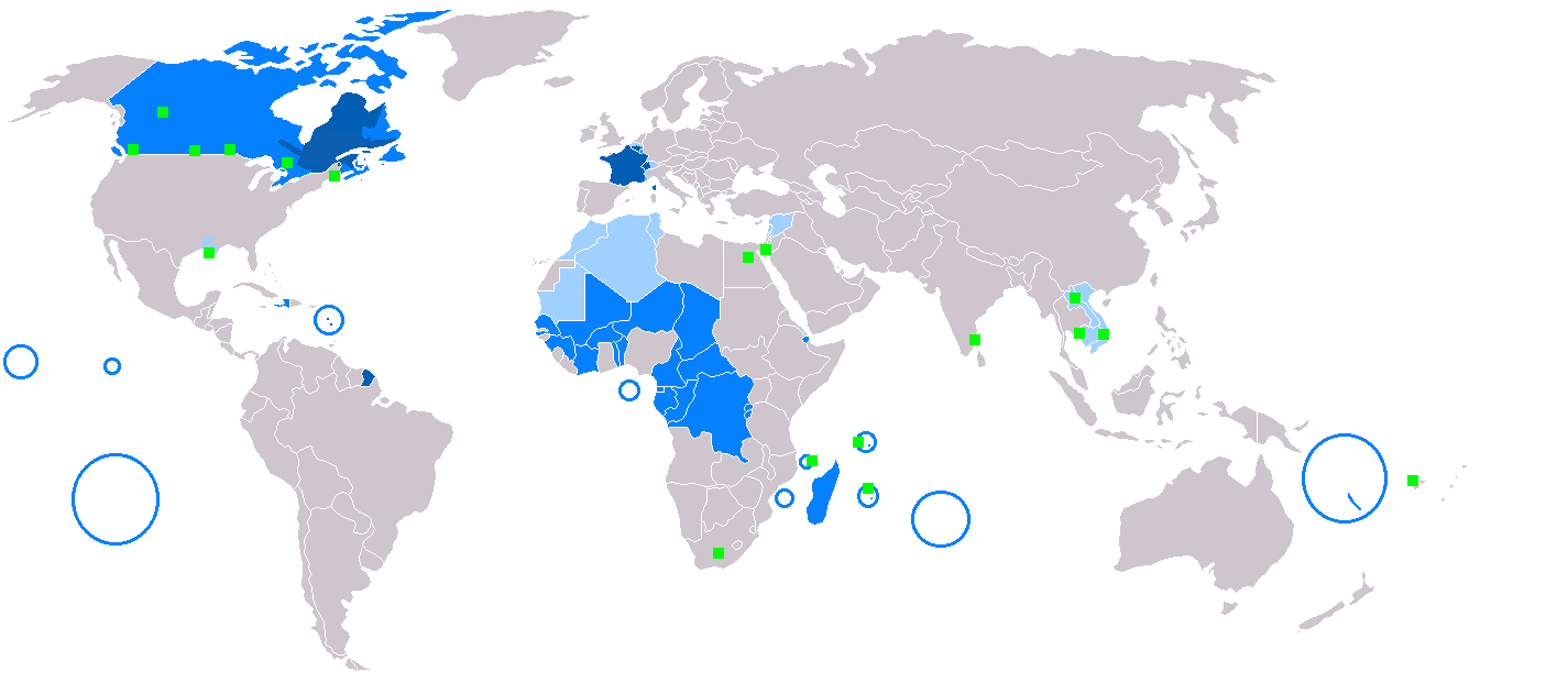
Map of Francophone world. Map made from Image:BlankMap-World.png
English legends:
██ native language
██ administrative language
██ secondary or non-official language
██ francophone minorities
Česky: Legenda:
- Tmavě modrá: domácí jazyk
- Modrá: správní jazyk
- Bledě modrá: druhotný nebo neoficiální jazyk
- Zelené čtverečky: frankofonní menšina
Deutsch: Legende:
- Dunkelblau: Muttersprache
- Blau: Amtssprache
- Hellblau: Nebensprache oder nicht offizielle Sprache
- grüne Quadrate: frankophone Minderheiten
Esperanto: Legendo:
- Malhelblua : gepatra lingvo
- Blua : administra lingvo
- Helblua : kultura lingvo
- Verda : franclingvaj minoritatoj
Español: Leyenda:
- Azul oscuro: lengua materna
- Azul: lengua administrativa
- Azul claro: segunda lengua o lengua no oficial
- Cuadrados verdes: minorías francófonas
Français : Carte du monde où on parle le français.
- Bleu foncé : langue maternelle
- Bleu : langue administrative
- Bleu clair : langue importante et/ou langue de culture
- Vert : minorités francophones
Italiano: Legenda:
- Blu scuro: lingua madre
- Blu: lingua amministrativa
- Blu chiaro: seconda lingua o lingua non ufficiale
- Quadrati verdi: minoranze francofone
Magyar: Színmagyarázat:
- Sötétkék: anyanyelv
- Kék: hivatalos nyelv/közigazgatás nyelve
- Világoskék: fontos második nyelv vagy kultúrnyelv
- Zöld: franciaajkú kisebbség
Nederlands: Het Frans in de wereld: legende
- Donkerblauw: moedertaal
- Blauw: bestuurstaal
- Lichtblauw: tweede taal of niet-officiële taal
- Groen: Franstalige minderheden
Norsk (bokmål): Fargekoder:
- Mørkeblått: Morsmål
- Blått: Administrativt språk
- Lyseblått: Andrespråk eller uoffisielt språk
- Grønt: Fransktalende minoriteter
Polski: Legenda:
- ciemnoniebieski: język ojczysty
- niebieski: język urzędowy
- jasnoniebieski: język kultury
- zielony: w mniejszości
Português: Legenda:
- Azul Escuro: Língua materna
- Azul: Língua administrativa
- Azul Claro: Segunda língua ou língua não oficial
- Quadrado verde: Minoria francofônica
Română: Legendă:
- Albastru închis: limbă maternă
- Albastru: limbă administrativă
- Albastru clar: Limbă secundară sau neoficială
- Pătratele verzi: minorităţi francofone
Suomi: Maailmankartta ranskaa puhuvista maista.
- Tummansininen: äidinkielenä
- Sininen: hallinnollisena kielenä
- Vaaleansininen: kulttuurillisesti merkittävä kieli
- Vihreä: ranskankielisiä vähemmistöjä
Svenska: Färgkoder:
- Mörkblå: Modersmål
- Blå: Administrativt språk
- Ljusblå: Andrahands- eller ickeofficiellt språk
- Gröna fyrkanter: Fransktalande minoriteter
Türkçe: Lejand:
- Koyu mavi: Anadil
- Mavi: Yönetim dili
- Açık mavi: İkinci ya da resmi olmayan dil
- Yeşil kareler: Fransızca konuşan azınlıklar
中文: 圖例:
- 深藍:本土語言
- 藍:行政語言
- 淺藍:第二或非官方語言
- 綠色正方形:少數講法語
Originaire par User:Eruedin.
[edit] Licensing
| This image has been released into the public domain by its author, Yug. This applies worldwide. In some countries this may not be legally possible; if so: العربية | Български | Deutsch | Ελληνικά | English | Español | Français | Italiano | 日本語 | 한국어 | Polski | Русский | Српски / Srpski | Svenska | தமிழ் | Українська | 中文(繁體) | 中文(简体) +/- |
Estorial el archivu
Pursa nuna fecha/ora pa vel cumu era el archivu nesi momentu.
| Fecha/Ora | Miias | Usuáriu | Comentáriu | |
|---|---|---|---|---|
| atual | 17:13, 6 Marçu 2008 | 1,425×631 (32 KB) | Arctic.gnome | (French is administrative in Canada and a secondary language in Andorra. I also added PEI and Manitoulin Island to Canada, and Saint Pierre, Miquelon and Sable islands around the Newfoundland coast.) |
| 17:09, 6 Marçu 2008 | 1,425×631 (50 KB) | Arctic.gnome | (Reverted to version as of 20:37, 22 January 2007) | |
| 17:08, 6 Marçu 2008 | 1,425×631 (32 KB) | Arctic.gnome | (== Summary == Map of Francophone world. Map made from Image:BlankMap-World.png '''English''' legends: {{legend|#0c5eb1|native language}} {{legend|#0080ff|administrative language}} {{legend|#9fceff|secondary or non-official langua) | |
| 20:37, 22 Eneru 2007 | 1,425×631 (50 KB) | IAMTHEEGGMAN | (Updating actual World Map and Adding Montenegro.) | |
| 22:13, 4 Diciembri 2006 | 1,357×631 (48 KB) | Aaker | (== Summary == Map of Francophone world. Map made from Image:BlankMap-World.png {{cs|Legenda: *Tmavě modrá: domácí jazyk *Modrá: správní jazyk *Bledě modrá: druhotný nebo neoficiální jazyk *Zelené čtverečky: frankof) | |
| 10:52, 19 Agostu 2006 | 1,357×631 (48 KB) | Dionysos1 | (more detailed internal borders of Belgium) | |
| 10:50, 19 Agostu 2006 | 1,357×628 (48 KB) | Dionysos1 | (Reverted to earlier revision) | |
| 10:49, 19 Agostu 2006 | 1,357×631 (48 KB) | Dionysos1 | (more detailed internal borders of Belgium) | |
| 09:59, 10 Agostu 2006 | 1,357×628 (48 KB) | Roke | (louisiana light blue for official language) | |
| 13:11, 26 Húniu 2006 | 1,357×628 (48 KB) | Roke | (remove ontario - several wikipedi talk page comments, move circle from puerto rico to guadeloupe and martiinique) | |
| 16:48, 21 Húniu 2006 | 1,357×628 (48 KB) | Jungpionier | ||
| 12:47, 11 Húniu 2006 | 1,357×628 (48 KB) | SEL | ||
| 12:39, 4 Húniu 2006 | 1,357×628 (48 KB) | Hexagon1 | (more detailed borders of Ontario and Quebec) | |
| 14:32, 13 Mayu 2006 | 1,357×628 (28 KB) | Colonel Cow | ||
| 21:32, 4 Hebreru 2006 | 1,357×628 (15 KB) | Kbolino | (53.1% of original file size (ran through pngrewrite, optipng, advpng, and pngout)) | |
| 23:14, 12 Diciembri 2005 | 1,357×628 (28 KB) | Yug | ||
| 13:02, 11 Diciembri 2005 | 1,357×628 (28 KB) | Yug | ||
| 21:04, 10 Diciembri 2005 | 1,357×628 (28 KB) | Yug | ||
| 14:06, 10 Diciembri 2005 | 1,357×628 (26 KB) | Yug | (Map of Francophone world. Map made from Image:BlankMap-World.png {{PD-user|Yug}} Category:World maps ) |
Atihus
Las siguientis páhinas atihan a esti archivu:

