See also ebooksgratis.com: no banners, no cookies, totally FREE.

CLASSICISTRANIERI HOME PAGE - YOUTUBE CHANNEL
Privacy Policy Cookie Policy Terms and Conditions
Pilt:Saue vald location.png - Vikipeedia, vaba entsüklopeedia

Pilt:Saue vald location.png

Allikas: Vikipeedia

Wikimedia Commonsi logo
See on jagatud fail ja asub Wikimedia Commonsis. Faili sealne kirjeldus on toodud allpool.

This is a file from the Wikimedia Commons. The description on its description page there is copied below.

The description on its file description page on the shared repository is shown below.

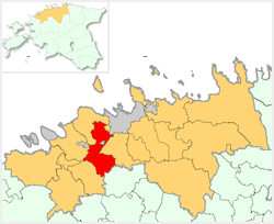
Location map of Saue Commune, Estonia.


This image was created by Senzeichi.
The image is licensed under a dual license, please choose either of the two licenses below as desired.
Creative Commons License
Creative Commons Attribution iconCreative Commons Share Alike icon
This file is licensed under the Creative Commons Attribution ShareAlike 2.5 License. In short: you are free to share and make derivative works of the file under the conditions that you appropriately attribute it, and that you distribute it only under a license identical to this one. Official license
GNU head Permission is granted to copy, distribute and/or modify this document under the terms of the GNU Free Documentation license, Version 1.2 or any later version published by the Free Software Foundation; with no Invariant Sections, no Front-Cover Texts, and no Back-Cover Texts. A copy of the license is included in the section entitled "GNU Free Documentation license".

Aragonés | العربية | Asturianu | Български | বাংলা | ইমার ঠার/বিষ্ণুপ্রিয়া মণিপুরী | Brezhoneg | Bosanski | Català | Cebuano | Česky | Dansk | Deutsch | Ελληνικά | English | Esperanto | Español | Eesti | Euskara | فارسی | Suomi | Français | Gaeilge | Galego | עברית | Hrvatski | Magyar | Bahasa Indonesia | Ido | Íslenska | Italiano | 日本語 | ქართული | ភាសាខ្មែរ | 한국어 | Kurdî / كوردی | Latina | Lëtzebuergesch | Lietuvių | Bahasa Melayu | Nnapulitano | Nederlands | ‪Norsk (nynorsk)‬ | ‪Norsk (bokmål)‬ | Occitan | Polski | Português | Română | Русский | Slovenčina | Slovenščina | Shqip | Српски / Srpski | Svenska | తెలుగు | ไทย | Türkçe | Українська | اردو | Tiếng Việt | Volapük | Yorùbá | ‪中文(中国大陆)‬ | ‪中文(台灣)‬ | +/-

Used location map of Harju County created by Siim.

File history

Click on a date/time to view the file as it appeared at that time.

Kuupäev/kellaaegMõõtmedKasutajaKommentaar
current12. august 2005, kell 23:33250×204 (11 KB)Senzeichi

Sellele pildile viitavad järgmised leheküljed:


aa - ab - af - ak - als - am - an - ang - ar - arc - as - ast - av - ay - az - ba - bar - bat_smg - bcl - be - be_x_old - bg - bh - bi - bm - bn - bo - bpy - br - bs - bug - bxr - ca - cbk_zam - cdo - ce - ceb - ch - cho - chr - chy - co - cr - crh - cs - csb - cu - cv - cy - da - de - diq - dsb - dv - dz - ee - el - eml - en - eo - es - et - eu - ext - fa - ff - fi - fiu_vro - fj - fo - fr - frp - fur - fy - ga - gan - gd - gl - glk - gn - got - gu - gv - ha - hak - haw - he - hi - hif - ho - hr - hsb - ht - hu - hy - hz - ia - id - ie - ig - ii - ik - ilo - io - is - it - iu - ja - jbo - jv - ka - kaa - kab - kg - ki - kj - kk - kl - km - kn - ko - kr - ks - ksh - ku - kv - kw - ky - la - lad - lb - lbe - lg - li - lij - lmo - ln - lo - lt - lv - map_bms - mdf - mg - mh - mi - mk - ml - mn - mo - mr - mt - mus - my - myv - mzn - na - nah - nap - nds - nds_nl - ne - new - ng - nl - nn - no - nov - nrm - nv - ny - oc - om - or - os - pa - pag - pam - pap - pdc - pi - pih - pl - pms - ps - pt - qu - quality - rm - rmy - rn - ro - roa_rup - roa_tara - ru - rw - sa - sah - sc - scn - sco - sd - se - sg - sh - si - simple - sk - sl - sm - sn - so - sr - srn - ss - st - stq - su - sv - sw - szl - ta - te - tet - tg - th - ti - tk - tl - tlh - tn - to - tpi - tr - ts - tt - tum - tw - ty - udm - ug - uk - ur - uz - ve - vec - vi - vls - vo - wa - war - wo - wuu - xal - xh - yi - yo - za - zea - zh - zh_classical - zh_min_nan - zh_yue - zu -