Imagen:Map of USA highlighting Sun Belt.png
De Wikipedia, la enciclopedia libre
No se dispone de una resolución más alta.
Map_of_USA_highlighting_Sun_Belt.png (280 × 183 píxeles; tamaño de archivo: 40 KB; tipo MIME: image/png)
| | Éste es un fichero de Wikimedia Commons, un depósito de contenido libre hospedado por la Fundación Wikimedia. Más abajo se reproduce su página de descripción con la información sobre su origen y licencia. |
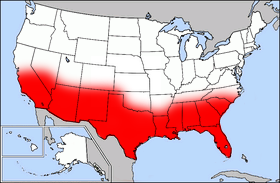
Public domain map courtesy of The General Libraries, The University of Texas at Austin, modified (by • Benc • 00:36, 13 Aug 2004 (UTC) to highlight regions.
Originally uploaded onto English Wikipedia 00:36, 13 August 2004 by Benc
| This file has been released into the public domain by the copyright holder, its copyright has expired, or it is ineligible for copyright. This applies worldwide. | |
Note: This tag is obsolete! Nothing is public domain without a reason. Don't use this generic template - please use instead:
العربية | Български | Česky | Deutsch | English | Español | Français | हिन्दी | Italiano | 日本語 | Norsk (bokmål) | Norsk (nynorsk) | Português | Русский | Slovenčina | Slovenščina | Српски / Srpski | Polski | Türkçe | 中文 | +/- |
Historial del archivo
Haga clic sobre una fecha/hora para ver el archivo a esa fecha.
| Fecha/Hora | Dimesiones | Usuario | Comentario | |
|---|---|---|---|---|
| act | 17:41 27 sep 2006 | 280×183 (40 KB) | Mr Bullitt | (Public domain map courtesy of [http://www.lib.utexas.edu/ The General Libraries, The University of Texas at Austin], modified (by • Benc • 00:36, 13 Aug 2004 (UTC)) to highlight regions. Originally uploaded ) |
Enlaces a la imagen
Las siguientes páginas enlazan a esta imagen:

