See also ebooksgratis.com: no banners, no cookies, totally FREE.

CLASSICISTRANIERI HOME PAGE - YOUTUBE CHANNEL
Privacy Policy Cookie Policy Terms and Conditions
Imagen:America noviter delineata.jpg - Wikipedia, la enciclopedia libre

Imagen:America noviter delineata.jpg

De Wikipedia, la enciclopedia libre


Wikimedia Commons Logo Éste es un fichero de Wikimedia Commons, un depósito de contenido libre hospedado por la Fundación Wikimedia.
Más abajo se reproduce su página de descripción con la información sobre su origen y licencia.

[edit] Summary

Description
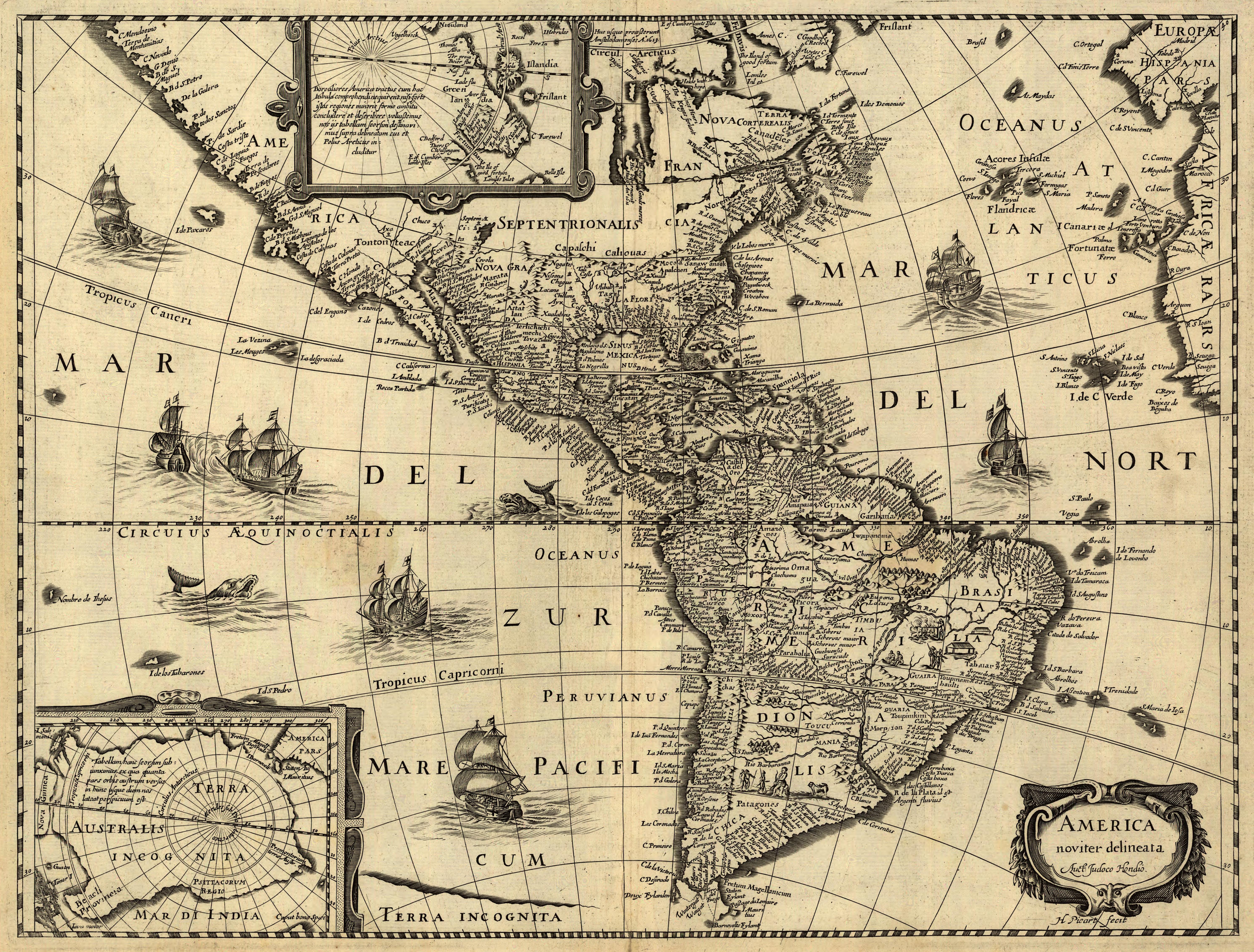
Latina: America noviter delineata / auct. Jodoco Hondio; H. Picard fecit.
English: America newly delineated / by Jodocus Hondius; engraved by H. Picard. A 17th-century map of the Americas. Scale ca. 1:45,000,000. Map ranges from W 125°–W 5° and N 70°–S 60°. Also includes insets of the polar regions.
Français : L'amérique nouvellement cartographiée / Par Jocodus Hondius; gravé par H. Picard. Une carte des amériques du XVIIe siècle. Echelle: environ 1:45 000 000. La carte couvre un espace allant de 5°W à 125°W et de 60°S à 70°N. Elle inclue aussi en encarts les régions polaires.
Source

Published by Jean Boisseau. The U.S. Library of Congress gives the date of publication as "1640?", while another source suggests a first publication of 1637 or 1639. Digital version produced by the U.S. Library of Congress Geography and Map Division. JPEG 2000 source image converted to JPEG by User:Delirium using JasPer 1.701.0, since JPEG 2000 is not as of this uploading supported on Commons.

This map is available from the United States Library of Congress's Geography & Map Division under the digital ID g3290.np000144
This tag does not indicate the copyright status of the attached work. A normal copyright tag is still required. See Commons:Licensing for more information.
Date

1637 to 1640

Author

Jodocus Hondius (1563-1612)

Permission
(Reusing this image)
This is a faithful photographic reproduction of an original two-dimensional work of art. The original image comprising the work of art itself is in the public domain for the following reason:
Public domain This image (or other media file) is in the public domain because its copyright has expired.

This applies to the United States, Canada, the European Union and those countries with a copyright term of life of the author plus 70 years.


Note that a few countries have copyright terms longer than 70 years: Mexico has 100 years, Colombia has 80 years, and Guatemala and Samoa have 75 years. This image may not be in the public domain in these countries, which moreover do not implement the rule of the shorter term. Côte d'Ivoire has a general copyright term of 99 years and Honduras has 75 years, but they do implement that rule of the shorter term.


العربية | Asturianu | Български | Català | Česky | Dansk | Deutsch | English | Ελληνικά | Esperanto | Español | Euskara | فارسی | Français | Gaeilge | Galego | עברית | हिन्दी | Bahasa Indonesia | Italiano | 日本語 | 한국어 | Kurdî / كوردی | Lietuvių | Magyar | Nederlands | ‪Norsk (nynorsk)‬ | Bahasa Melayu | Polski | Português | Română | Русский | Slovenčina | Slovenščina | Shqip | Suomi | Sámegiella | Türkçe | ‪中文(简体)‬ | ‪中文(繁體)‬ | 粵語 | +/-

Under United States copyright law, originality of expression is necessary for copyright protection, and a mere photograph of an out-of-copyright work may not be protected under U.S.copyright law. This photograph was taken in the U.S. or in another country where a similar rule applies (for a list of allowable countries, see Commons:When to use the PD-Art tag#Country-specific rules).
This photographic reproduction is therefore also in the public domain.

العربية | Česky | Deutsch | English | Ελληνικά | Español | فارسی | Français | עברית | Bahasa Indonesia | Italiano | 日本語 | 한국어 | Magyar | Nederlands | Polski | Português | Română | Русский | Slovenščina | Српски / Srpski | Basa Sunda | Türkçe | Українська | ‪中文(繁體)‬ | ‪中文(简体)‬ | +/-

Other versions None

[edit] Awards

Picture of the day This image was selected as a picture of the day for April 17, 2007. It was captioned as followed:
English: America noviter delineata, a 17th-century map of the Americas by Jodocus Hondius

Беларуская: America noviter delineata, карта Амерыкі, створаная ў XVII ст. Ёдакусам Хондзіюсам.
Česky: Mapa kartografa Jodocuse Hondiusa (1563-1611) America noviter delineata
Deutsch: America noviter delineata, eine Amerikakarte des 17. Jahrhundert von Jodocus Hondius
English: America noviter delineata, a 17th-century map of the Americas by Jodocus Hondius
Esperanto: America noviter delineata, mapo de Ameriko desegnita en la 17-a jarcento de Jodocus Hondius.
Español: America noviter delineata, un mapa de América del siglo XVII realizado por Jodocus Hondius.
Suomi: America noviter delineata, Jodocus Hondiuksen tekemä Amerikankartta 1600-luvulta
Français : America noviter delineata, une carte du 17è siècle des Amériques, dressée par Jodocus Hondius
Magyar: America noviter delineata, 17. századi térkép Amerikáról, Jodocus Hondiusalkotása
Italiano: America noviter delineata, una mappa delle Americhe realizzata nel XVII secolo da Jodocus Hondius.
日本語: America noviter delineataJodocus Hondiusによる17世紀のアメリカの地図
Nederlands: America noviter delineata, kaart uit de 17e eeuw van het continent Amerika door de cartograaf Jodocus Hondius
Polski: America noviter delineata, siedemnastowieczna mapa Ameryki autorstwa Jodocusa Hondiusa (1563-1611)
Русский: America noviter delineata, карта Америки, созданная в XVII веке Юдокусом Хондиусом.
Slovenčina: Mapa kartografa Jodocusa Hondiusa (1563-1611) America noviter delineata
Svenska: America noviter delineata är en karta över Amerika ritad på 1600-talet av den flamländske kartografen Jodocus Hondius.
‪中文(简体)‬: 17世纪时约道库斯·洪地乌斯绘制的《最新美洲地图
‪中文(繁體)‬: 17世紀時由約道庫斯·洪地烏斯繪製的《最新美洲地圖》

POTY
Featured picture
This file was a candidate on Picture of the Year 2006.
This is a featured picture on Wikimedia Commons: it is considered one of our finest images.
If you have an image of similar quality that can be published under a suitable copyright license, be sure to upload it, tag it, and nominate it.
Wikimedia Commons

Historial del archivo

Haga clic sobre una fecha/hora para ver el archivo a esa fecha.

Fecha/HoraDimesionesUsuarioComentario
act06:33 14 jun 20065.965×4.528 (5,17 MB)Delirium (''America noviter delineata / auct. Jodoco Hondio; H. Picard fecit.'' (America newly delineated / by Jodoco Hondia; engraved by H. Picard.) A 17th-century map of the Americas. Scale ca. 1:45,000,000. Map ranges from W 125°–W 5° and N 70&d)


aa - ab - af - ak - als - am - an - ang - ar - arc - as - ast - av - ay - az - ba - bar - bat_smg - bcl - be - be_x_old - bg - bh - bi - bm - bn - bo - bpy - br - bs - bug - bxr - ca - cbk_zam - cdo - ce - ceb - ch - cho - chr - chy - co - cr - crh - cs - csb - cu - cv - cy - da - de - diq - dsb - dv - dz - ee - el - eml - en - eo - es - et - eu - ext - fa - ff - fi - fiu_vro - fj - fo - fr - frp - fur - fy - ga - gan - gd - gl - glk - gn - got - gu - gv - ha - hak - haw - he - hi - hif - ho - hr - hsb - ht - hu - hy - hz - ia - id - ie - ig - ii - ik - ilo - io - is - it - iu - ja - jbo - jv - ka - kaa - kab - kg - ki - kj - kk - kl - km - kn - ko - kr - ks - ksh - ku - kv - kw - ky - la - lad - lb - lbe - lg - li - lij - lmo - ln - lo - lt - lv - map_bms - mdf - mg - mh - mi - mk - ml - mn - mo - mr - mt - mus - my - myv - mzn - na - nah - nap - nds - nds_nl - ne - new - ng - nl - nn - no - nov - nrm - nv - ny - oc - om - or - os - pa - pag - pam - pap - pdc - pi - pih - pl - pms - ps - pt - qu - quality - rm - rmy - rn - ro - roa_rup - roa_tara - ru - rw - sa - sah - sc - scn - sco - sd - se - sg - sh - si - simple - sk - sl - sm - sn - so - sr - srn - ss - st - stq - su - sv - sw - szl - ta - te - tet - tg - th - ti - tk - tl - tlh - tn - to - tpi - tr - ts - tt - tum - tw - ty - udm - ug - uk - ur - uz - ve - vec - vi - vls - vo - wa - war - wo - wuu - xal - xh - yi - yo - za - zea - zh - zh_classical - zh_min_nan - zh_yue - zu -