
Image:Main towns in the province of Valencia.png
From Wikipedia, the free encyclopedia
No higher resolution available.
Main_towns_in_the_province_of_Valencia.png (524 × 535 pixels, file size: 108 KB, MIME type: image/png)
| | This is a file from the Wikimedia Commons. The description on its description page there is shown below.
|
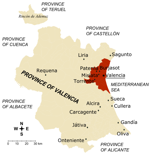
Map of the province of Valencia (Spain)
- The inner city and the towns conforming the first crown of Valencia metropolitan area are drawn in dark brown; together, they concentrate 60.62% of the province population in 5.73% of its surface, with a mean density of 2.407 hab/km2.
- The towns marked on the map are those with more than 30,000 inhabitantes (if they belong to Valencia metropolitan area) or more than 20,000 inhabitants (for the rest of towns), according to 2005 census.
- Author: Rodriguillo
- Realised from: Image:Valencia - Mapa municipal.svg
- Other versions: español, français
| This image has been released into the public domain by its author, Rodriguillo. This applies worldwide. In some countries this may not be legally possible; if so: العربية | Български | Deutsch | Ελληνικά | English | Español | Français | Italiano | 日本語 | 한국어 | Polski | Русский | Српски / Srpski | Svenska | தமிழ் | Українська | 中文(繁體) | 中文(简体) +/- |
File history
Click on a date/time to view the file as it appeared at that time.
| Date/Time | Dimensions | User | Comment | |
|---|---|---|---|---|
| current | 14:31, 10 December 2006 | 524×535 (108 KB) | Rodriguillo | ('''Map of the province of Valencia''' (Spain) * The inner city and the towns conforming the first crown of Valencia metropolitan area are drawn in dark brown; together, they concentrate 60.62% of the province population in 5.73% of its surface, wi) |
File links
The following pages on the English Wikipedia link to this file (pages on other projects are not listed):

