
Image:Karte limes.jpg
From Wikipedia, the free encyclopedia
No higher resolution available.
Karte_limes.jpg (800 × 536 pixels, file size: 135 KB, MIME type: image/jpeg)
| | This is a file from the Wikimedia Commons. The description on its description page there is shown below.
|
| Description |
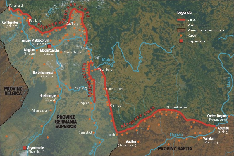
English: Map shows location of the Rhaetian and Upper Germanic Limes
Deutsch: Darstellung zeigt den Verlauf des rätischen und obergermanischen Limes.
|
|---|---|
| Source | |
| Date |
2004 |
| Author | |
| Permission (Reusing this image) |
GFDL /
English: Please quote source and send an notice to sansculotte@despammed.com
Deutsch: Quellenangabe und Beleg an sansculotte@despammed.com erbeten.
|
[edit] History (from de.wikipedia.org)
- (Löschen) (Aktuell) 04:45, 18. Feb 2004 . . Sansculotte (Diskussion) . . 800 x 536 (138.662 Byte)
- (Löschen) (Zurücksetzen) 19:16, 17. Feb 2004 . . Sansculotte (Diskussion) . . 800 x 536 (140.769 Byte) (eigene Darstellung, 08/2003 A. Darmochwal. Karte ist im Sinne der GNU FDL frei verwendbar. Quellenangabe und Beleg erbeten.)
- (Löschen) (Zurücksetzen) 22:49, 16. Feb 2004 . . Sansculotte (Diskussion) . . 800 x 536 (94.228 Byte) (eigene Darstellung)
[edit] Licensing

File history
Click on a date/time to view the file as it appeared at that time.
| Date/Time | Dimensions | User | Comment | |
|---|---|---|---|---|
| current | 07:15, 3 June 2005 | 800×536 (135 KB) | Longbow4u | (*{{English}}: **'''Description''': Map shows location of the Rhaetian and Upper Germanic Limes. **'''Author''': de:Benutzer:Sancsulotte, drawn himself in 2004 , upload to German wikipedia 17.02.2004 '''Please quote source and send an notice to [mailt) |
File links
The following pages on the English Wikipedia link to this file (pages on other projects are not listed):

