
Talk:French India
From Wikipedia, the free encyclopedia

Contents |
[edit] french control?

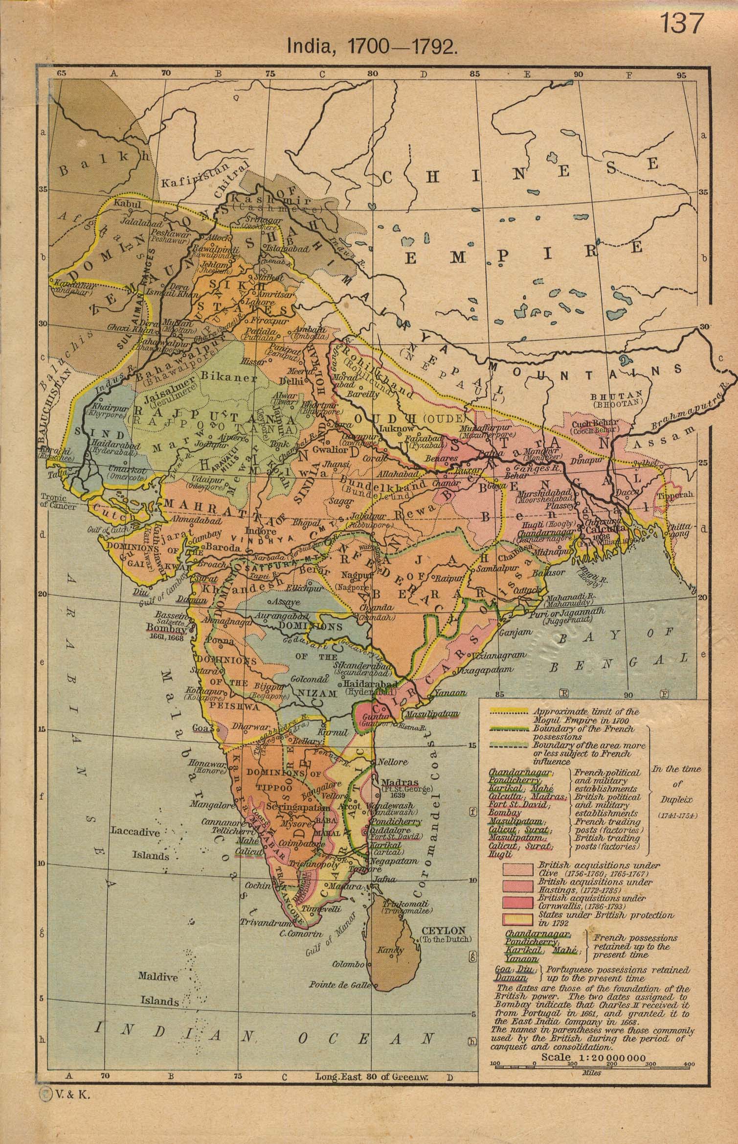
This map shows a large area of French control in India. Is the map correct because the article doesnt seem to mention as large an area as this? -- Astrokey44|talk 12:39, 9 February 2006 (UTC)
- I found a map here that seems to confirm that the French had the large area in the 1740's, but they didn't hold on to it for long. Kmusser 20:05, 11 May 2006 (UTC)
Hello Kmusser,
I don't mean to dig up a previously discussed point, but I do agree with the previous contributor. Although you (I presume you compiled the aesthetically pleasing maps) accurately indicate French dominions and influence on the India map, the world map mistakenly portrays areas of French influence as part of the French Empire. I'm afraid that is not supported by the map or by historical fact. After all, Hyder Ali, the Nizam, and the Marathas were all independent rulers until their defeat/treaties with the British. Although Dupleix was an effective and cunning imperialist, I think we give him a little more credit than he is due with that map. Moreover, due to this map, the French world empire article notes that half of India was under French rule, which of course isn't true. Please let me know what your thoughts are and if the changes can be made by you or someone else. Thanks for your understanding.
Best Regards,
Devanampriya 06:48, 11 March 2007 (UTC)
- I agree, that area probably should be hatched to show French influence instead of control like they did for China. There is also comment on the image page that a portion of Thailand should be hatched as well. That one isn't one of my maps though - it was made by User:Yug, who I believe is still active. I'd rather not change it if he is willing to do it himself.Kmusser 13:41, 16 March 2007 (UTC)
- I didn't made it. I'm an administrator on Wiki-fr and particuraly on historical topics. When I found this map on Wiki-en, I moved it from En to Commons. I only did that. From what I know about France in India, we only had the control over some indians cities. But it may be that all the area was, in a time, under french influence. I know no more. Have you some informations ? Indian's people should be able to help you. See :
- Yug (talk) 20:15, 19 March 2007 (UTC)
- ok, I went ahead and edited it, hopefully that is an improvement. Kmusser 20:55, 19 March 2007 (UTC)
Hello Kmusser,
Thank you for stepping in to manage this. I take it from your reference to France in India as "we" that you are of French origin. However, I do think we should distinguish between French Territory "i.e. Chandernagore, Pondicherry, Yanam" and French Allies, i.e. Hyder Ali/Tipu Sultan. Although there is a difference between the French Sphere of Influence in China and areas of India where the French had strong diplomatic relations under Dupleix. The regions that are covered there were independent kingdoms under the Nizam of Hyderabad, Hyder Ali/Tipu, and the Marathas. The dark blue territories are correct, from what I understand. I appreciate your edits, however, I would suggest a rewording. The caption discussing light blue should denote "french allies or french influence" whereas dark blue should designate actual territory in "French India". Sorry the hatched and the solid seem to blend in on the map. The French were indeed on the cusp of serious empire in India, but the British put an end to that. Although I could make the changes myself, I would like to defer to you since you are the admin.
Best Regards,
Devanampriya 18:38, 20 March 2007 (UTC)
- The light blue refers to the first colonial empire and the dark blue refers to the second colonial empire - as discussed in French colonial empires which I think is the article this map was designed for. The solid versus hatched differentiates between possessions and areas of influence. Sorry I can't make that much clearer on the map - I'm stuck with the resolution of the base map. Feel free to edit the caption yourself - this is way outside my area of expertise. I'm not an admin, I just know how to use Photoshop :-) Kmusser 19:21, 20 March 2007 (UTC)
- I went ahead and took the map out of this article entirely, it dates from before Astrokey44's much better map was added and doesn't really serve a purpose here. Kmusser 19:46, 20 March 2007 (UTC)
[edit] Flag
I changed the flag from Image:Flag_of_Colonial_Vietnam.svg to Image:Ministre-DOMTOM.gif. The reasoning is that the colonies were administered as Territoire d'outre-mer of France from 1946 and not as part of French Indo-China.--Victor D PARLE 00:12, 26 April 2007 (UTC)
[edit] Regardinf flag
Only in during 4th republic it was made a TOM of France. It never had any particluar flag. Even, I am searching for it. So, its always best to keep the French flag, which clearly mentions the French soverignty during that period.Bsskchaitanya 07:20, 27 April 2007 (UTC)
[edit] I try to resolve the conflict
The map which shows the french influence is correct. When you people referring about maharattas and hyder ali, i think you need to go back to the history a little bit earlier. The light blue is comprised of Deccan region (ruled by Nizam of Hyderabad) and Carnatic region (ruled by Nawab of Carnatic). These two kingdoms are most crutial in the history of colonial India. It was not only French, but the British also tried their best to influence both kingdoms. Only by winning the dominance in these regions, the dream of establishing an English Empire was realized by Robert Clive. The Dark blue means the real possessions by French. The upper one (also known as Northern Circars was ceded by Nizam of Hyderabad, Salabat Jung to Marquis de Bussy in 1753. The down ones were territories won by Dupleix By battles at Ambour and Gingy between 1747 and 1749.
If you have any minutest doubts regarding French India, you can contact me. I am an native of Yanaon, an french colony and even I am writing a book "La histoire colonial de Yanaon" and going to submit it to Govt of Pondicherry next year. You can visit my userpage and read my articles to get a better understanding of history of Inde française.
Using the word french influence is correct, because only by that Salabat Jung became the Nizam of Hyderabad in 1751 and Chanda Sahib, the de-facto Nawab of Carnatic between 1749 and 1753.
Somebody termed Dupleix as cunning. I take pity on them, before talking anything you need to have a solid proof for what you talk. Wikipedia is not a place to comment upon, but to present the valid information. He was a beloved leader for not only french counterparts but also for the native indians of his time at Pondichéry. When he was leaving pondichéry, many native indians bid farewell to him with tears. I dont know how many indians now-a-days are serving for their motherland, but he definitely lived and died for his France.
Bsskchaitanya 06:35, 27 April 2007 (UTC)
[edit] Names
Why is "Puducherry" used throughout the article for a place that the French never called by that name? It's as anachronistic as, oh, trying to rename the Bombay Presidency to the "Mumbai Presidency". RandomCritic 06:10, 25 September 2007 (UTC)
[edit] WikiProject class rating
This article was automatically assessed because at least one WikiProject had rated the article as start, and the rating on other projects was brought up to start class. BetacommandBot 17:57, 9 November 2007 (UTC)
[edit] De facto switch to Indian control
This is an interesting article. I'd like to see more about the _de facto_ switch to Indian control in 1954. How did it happen? What was the status of Pondicherry between 1954 and the _de jure_ ceding by France in 1963? Ferg2k (talk) 15:34, 28 March 2008 (UTC)
[edit] Second Map is quite wrong
The second map in the article (Image:French Empires.png) is quite wrong, since it includes Spain and Portugal (and probably others) as part of the French Empire. Portugal and Spain were never part of any French Empire! They were countries briefly and non-completely occupied by Napoleonic forces in the begining of the 19th century. Being partially occupied is not the some as being part of an Empire. Both Spain and Portugal never stoped being independent and were never considered, even by France as a part of France or a colony! I'm removing this map. And replacing it with a correct one. The Ogre (talk) 23:16, 16 April 2008 (UTC)

