
Image:Color Revolutions Map.png
From Wikipedia, the free encyclopedia
No higher resolution available.
Color_Revolutions_Map.png (348 × 207 pixels, file size: 19 KB, MIME type: image/png)
| | This is a file from the Wikimedia Commons. The description on its description page there is shown below.
|
| Description |
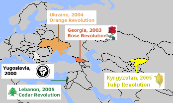
English: Map of en:Color Revolutions. Created by en:User:Aris Katsaris. Tulip image snatched from en::Image:Illustration Tulipa sylvestris0.jpg which is under a GFDL license. I made a choice not to include "Purple Revolution", because (outside a Bush quote) it doesn't seem widely accepted as part of the series.
|
|---|---|
| Source |
Transfered from en.wikipedia Transfer was stated to be made by User:TCY. |
| Date |
2005-04-01 (first version); 2007-09-16 (last version) |
| Author |
Original uploader was Aris Katsaris at en.wikipedia Later version(s) were uploaded by 159753, Avala at en.wikipedia. |
| Permission (Reusing this image) |
GFDL-WITH-DISCLAIMERS; Released under the GNU Free Documentation License. |
[edit] License information
 |
Permission is granted to copy, distribute and/or modify this document under the terms of the GNU Free Documentation License, Version 1.2 or any later version published by the Free Software Foundation; with no Invariant Sections, no Front-Cover Texts, and no Back-Cover Texts. Subject to disclaimers. Asturianu | Български | Català | Deutsch | English | Español | Français | Gaeilge | Italiano | 한국어 | 日本語 | Polski | Português | Română | Türkçe | +/- |
[edit] Original upload log
The original description page is/was here. All following user names refer to en.wikipedia.
- 2007-09-16 23:19 Avala 348×207×8 (20891 bytes)
- 2005-05-03 15:32 159753 348×207×8 (15697 bytes) Map of Color Revolutions. Created by User:Aris Katsaris. Tulip image snatched from Image:Illustration Tulipa sylvestris0.jpg which is under a GFDL license. I made a choice not to include "Purple Revolution", because (outside a Bush quote) it doesn't seem
- 2005-05-03 15:29 159753 348×207×8 (15697 bytes) {{GFDL}}
- 2005-04-01 17:29 Aris Katsaris 348×207×8 (12773 bytes) Correction: Yugoslavia instead of Serbia.
- 2005-04-01 17:04 Aris Katsaris 348×207×8 (12654 bytes) Map of [[Color Revolution]]s. Created by [[User:Aris Katsaris]]. Tulip image snatched from [[:Image:Illustration Tulipa sylvestris0.jpg]] which is under a GFDL license. I made a choice not to include "Purple Revolution", because (outside a Bush quote) it
File history
Click on a date/time to view the file as it appeared at that time.
| Date/Time | Dimensions | User | Comment | |
|---|---|---|---|---|
| current | 09:07, 16 March 2008 | 348×207 (19 KB) | Hoshie | (added internal Serbia-Mont. boundary in light gray as the FRY was not recognized as a (successor) state (to communist Yugoslavia) by some nations and the UN until after Milosevic was ousted in 2000) |
| 06:53, 20 December 2007 | 348×207 (20 KB) | TCY | ({{Information |Description={{en|Map of en:Color Revolutions. Created by en:User:Aris Katsaris. Tulip image snatched from en::Image:Illustration Tulipa sylvestris0.jpg which is under a GFDL license. I made a choice not to include "Purple Re) |
File links
The following pages on the English Wikipedia link to this file (pages on other projects are not listed):

