
Chilubi
From Wikipedia, the free encyclopedia

Chilubi is a settlement on an island in Lake Bangweulu and its swamps, and is headquarters of an administrative district of the same name in the Northern Province of Zambia.
Contents |
[edit] Chilubi Island
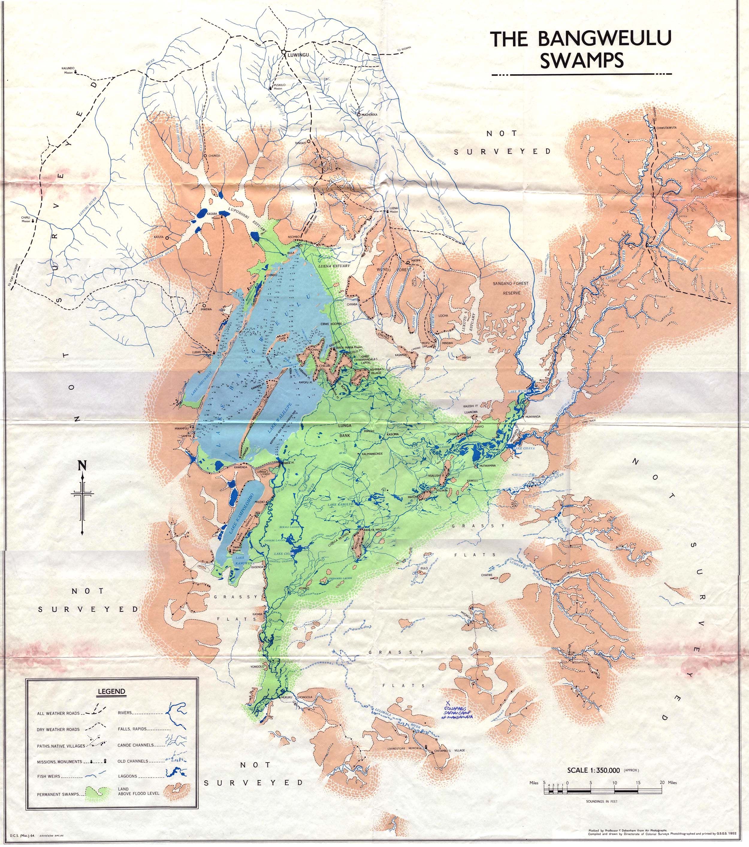
Chilubi Island lies just north of the centre of the eastern side of the lake. It has an unusual zig-zag shape of about five segments, each about 12 km long and 1.5 to 3 km wide. It resembles a Chinese dragon with its head (at the north-west end) just in the open lake and its body and tail (south-east end) in the swamps. The shortest distance on land from nose to tail is 25 km, and it has about 100 km of shoreline. [1] The smaller Nsumbu Island lies 1 km south-east of Chilubi Island.
The shores of Chilubi Island are lined with villages while the interior consists of patches of wooded grassland. The soil is very sandy and infertile, so not much food is grown on the island. There are only a few vehicles or tracks but it is cross-crossed by footpaths.[1] The main settlements on Chilubi Island are Chilubi, Muchinchi, Chiwanangala (headquarters of the chief of that name) and Santa Maria, a Catholic mission. [2]
The island is served by passenger ferries from Samfya and Nsombo in Luwingu District and Chaba at the north end of the lake, and there is an airstrip at the mission,
The main occupation of the island is fishing, with some employment provided by schools, a health centre, the District Council and the mission.
[edit] Chilubi town
The town or large village is situated at the most north-westerly tip of the island. Chilubi is 45 km across the lake from Samfya, 28 km from Chaba and 38 km from Nsombo. Chilubi is unique in Zambia, being the only one of the 72 district headquarters or bomas on an island, with no road connections.[1] A boma was first established during colonial times at the southern tip of the island.[3]
[edit] Chilubi District
Chilubi District covers the north-east Lake Bangweulu and Bangweulu swamps containing several islands including Chilubi Island, and some of the mainland northeast of the lake. Like Samfya District most of it is lake or swamp, and the rest rural and less developed than Samfya, lacking roads and infrastructure. The only road connections for its mainland part is a dirt road from Luwingu in the north to Mofu and Chaba. Swamps of the Lukulu, Lubansenshi, and Chambeshi Rivers cut the district off on its eastern side.[1] Channels have been cut through the swamps in many places to aid navigation by boat. Since they share the lake and swamps, geographically Chilubi District has more in common with Samfya District in Luapula Province than it does with the rest of Northern Province. Most travellers leaving the district go by boat to Nsombo then by gravel road to Kasama via Luwingu, or by boat to Samfya then by all-weather road to Mansa or Serenje.
Other islands in Chilubi District include Chichile, Kasansa, Panyo and Luangwa, all at the edges of the swamps where they dry out sufficiently in the dry season to form a connection to the mainland.[3]
Isangano National Park lies in the east of the district but it has no management and most of the wildlife has been poached out.[4]
[edit] See also
[edit] References
- ^ a b c d Google Earth Shoreline measured at 1 km centres.
- ^ Terracarta/International Travel Maps, Vancouver Canada: "Zambia, 2nd edition", 2000.
- ^ a b NRZAM.org website: Directorate of Colonial Surveys: Map of Bangweulu Swamps (1952). Accessed 24 April 2007.
- ^ Camerapix: "Spectrum Guide to Zambia." Camerapix International Publishing, Nairobi, 1996.
| This Zambia location article is a stub. You can help by expanding it. |

