Bild:Altamaha watershed.png
aus Wikipedia, der freien Enzyklopädie
Keine höhere Auflösung vorhanden.
Altamaha_watershed.png (300 × 337 Pixel, Dateigröße: 110 KB, MIME-Typ: image/png)
| | Diese Datei wird aus dem zentralen, mehrsprachigen Dateiarchiv Wikimedia Commons eingebunden. Sämtliche Informationen unter dem roten Trennstrich stammen von der dortigen Beschreibungsseite der Datei. | |
[edit] Summary
| Description |
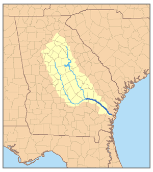
This is a map of the Altamaha River system. I, Pfly, created it based on USGS data. |
|---|---|
| Source |
Own work. |
| Date |
January 5, 2007 |
| Author | |
| Permission (Reusing this image) |
see below |
[edit] Licensing
|
Dateiversionen
Klicke auf einen Zeitpunkt, um diese Version zu laden.
| Version vom | Maße | Benutzer | Kommentar | |
|---|---|---|---|---|
| aktuell | 06:25, 6. Jan. 2007 | 300×337 (110 KB) | Pfly | ({{Information |Description=This is a map of the Altamaha River system. I, Pfly, created it based on USGS data. |Source=Own work. |Date=January 5, 2007 |Author=Pfly |Permission= |other) |
Verwendung
Die folgende Seite verwendet diese Datei:

