Image:Jamesrivermap.png
Fram Wikipedian
No higher resolution available.
Jamesrivermap.png (300 × 250 pixel, file size: 27 KB, MIME type: image/png)
[edit] Summary
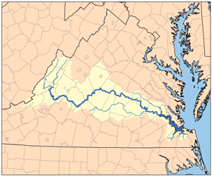
This is a map of the James River Watershed I made using USGS and Census Bureau data.
[edit] Licensing
|
File history
Click on a date/time to view the file as it appeared at that time.
| Date/Time | Brūcend | Dimensions | File size | Comment | |
|---|---|---|---|---|---|
| current | 17:07, 12 Sēremōnaþ 2006 | Kmusser | 300×250 | 27 KB | == Summary == This is a map of the James River Watershed I made using USGS and Census Bureau data. Category:Maps of rivers == Licensing == {{s |
Biliþbendas
Þā folgendan trametas bindaþ tō þissum biliðe:

